| WPC Met Watch |
|
|
Mesoscale Precipitation Discussion: #0448 (2019) |
|
(Issued at 301 PM EDT Tue Jun 18 2019
) |
|
| MPD Selection |
|
|
|
|
|

Mesoscale Precipitation Discussion 0448
NWS Weather Prediction Center College Park MD
301 PM EDT Tue Jun 18 2019

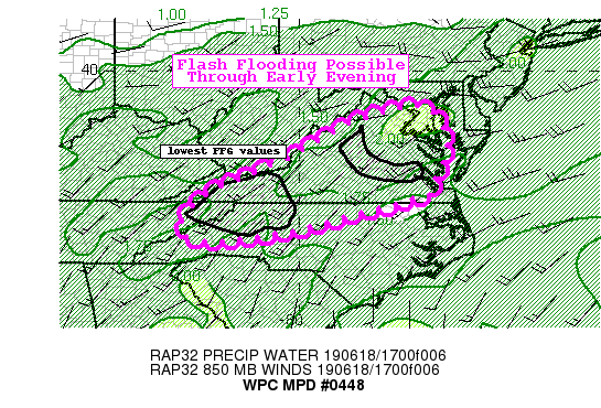
Areas affected...North Carolina...Virginia

Concerning...Heavy rainfall...Flash flooding possible

Valid 181901Z - 190101Z

Summary...Developing convection this afternoon in a very unstable
and moist environment poses a flash flood risk across portions of
North Carolina and Virginia.

Discussion...Shortwave energy coming out of the southern/central
Appalachians early this afternoon per latest water vapor imagery
is providing the necessary forcing for ascent for thunderstorm
development across portions of eastern TN, NC, and VA. The outlook
area is characterized by a very warm and moist environment with
the latest RAP mesoanalysis showing 3000-4000 J/kg of SBCAPE.
Dewpoints in the lower to middle 70s exist across much of the area
and the latest TPW product shows PWs of 1.6 to 1.8 inches.

This activity is expected to move east/northeast into a more
favorable environment coincident with peak heating. It should also
move into a better shear environment with effective shear values
of 30-35 kts, especially over central to northern Virginia. The
latest round of hi-res guidance shows several localized swaths of
1-3 inches with localized 4 inch amounts possible.

The 12z HREF shows the highest probabilities of exceeding 2-3
inches in 1 hour to be across northern Virginia later this
afternoon, but also shows moderate probabilities of 2"/hr across
western VA along the terrain areas. This is where the FFG is the
lowest as well.

Overall, given the more widespread coverage of storms moving into
a very unstable environment and the potential for intense rates
around urban areas, some flash flooding will be possible through
early evening.

Taylor

ATTN...WFO...AKQ...GSP...LWX...MRX...RAH...RNK...

ATTN...RFC...LMRFC...MARFC...OHRFC...SERFC...

LAT...LON   39097707 38817647 38297623 37827618 37247647
            36797659 36807675 36557738 36327839 35818033
            35598266 36108302 36798240 37108171 37358109
            37887998 38277932 38577882 38717843
Last Updated: 301 PM EDT Tue Jun 18 2019
|


