| WPC Met Watch |
|
|
Mesoscale Precipitation Discussion: #0456 (2022) |
|
(Issued at 109 AM EDT Wed Jul 06 2022
) |
|
| MPD Selection |
|
|
|
|
|

Mesoscale Precipitation Discussion 0456
NWS Weather Prediction Center College Park MD
109 AM EDT Wed Jul 06 2022

Areas affected...Northern IL...Northern IN...Far Southern
MI...Much of OH...Northwest WV

Concerning...Heavy rainfall...Flash flooding likely

Valid 060508Z - 061045Z

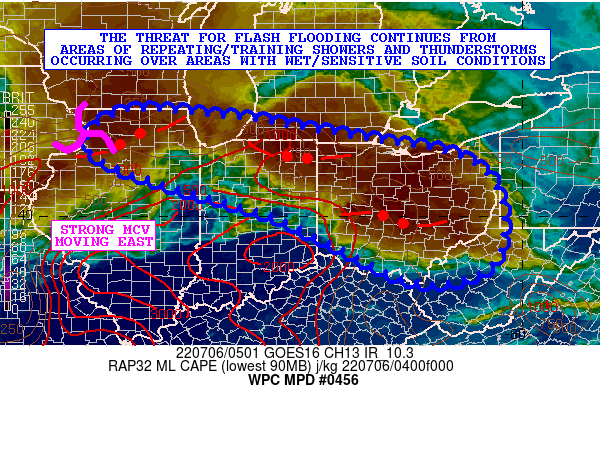
SUMMARY...The threat of flash flooding continues from areas of
repeating and locally training showers/thunderstorms occurring
over areas with wet/sensitive soil conditions.

DISCUSSION...The latest GOES-16 IR satellite imagery shows
multiple convective complexes advancing east and southeast across
the Upper Midwest and the OH Valley, with radar imagery confirming
multiple areas of repeating and training showers and
thunderstorms. All of this activity is being facilitated by
smaller scale MCVs and associated energy traversing the north side
of the subtropical ridge over the southern U.S.

Each of the aforementioned vort impulses are interacting with a
very moist and unstable airmass pooling northeastward up across
the OH Valley ahead of a frontal zone draped over the Great Lakes
region. Multiple outflow boundaries from earlier convection are
also in place making for some rather complex convective evolution.

The latest RAP analysis shows as much as 2000 to 3000 j/kg of
MLCAPE focusing from southern IL up into western and central IN.
This is generally the axis of the most unstable air over the OH
Valley and is preceding the strongest of all of the MCVs which is
moving now into northwest IL. Persistent warm air advection is
expected to continue through the remainder of the night which will
transport at least moderate instability downstream into much of OH
and gradually areas of northwest WV where there has been already
been multiple rounds of showers and thunderstorms over the last 12
to 24 hours.

PWs of 1.75 to 2.0 inches are in place, and this coupled with the
instability should continue to favor convection with heavy
rainfall rates that may approach or locally exceed 2 inches/hour.
The latest hires model guidance shows the potential for locally as
much as 3 to 4 inches of additional rain overnight, with the
expectation going toward dawn that the ongoing array of convective
complexes will gradually weaken as boundary layer stabilization
becomes more prevalent.

Many areas across northern IL, through northern IN and down into
central OH have seen a significant moistening of the ground over
the last 24 hours from heavy rainfall. These additional rains
occurring over the wet and sensitive soil conditions is likely to
encourage some enhanced runoff concerns. As a result, additional
areas of flash flooding are likely to occur overnight before
conditions improve later this morning.

Orrison

ATTN...WFO...CLE...DTX...DVN...GRR...ILN...ILX...IND...IWX...
LOT...PBZ...RLX...

ATTN...RFC...NCRFC...OHRFC...NWC...

LAT...LON   42478879 42288661 42058521 41778357 41538194
            41098093 40198045 38938064 38448184 38658304
            39398450 40038587 40728825 41148943 41509009
            41939010 42388947
Last Updated: 109 AM EDT Wed Jul 06 2022
|


