| WPC Met Watch |
|
|
Mesoscale Precipitation Discussion: #0463 (2019) |
|
(Issued at 320 AM EDT Thu Jun 20 2019
) |
|
| MPD Selection |
|
|
|
|
|

Mesoscale Precipitation Discussion 0463
NWS Weather Prediction Center College Park MD
320 AM EDT Thu Jun 20 2019

Areas affected...KY into northern TN

Concerning...Heavy rainfall...Flash flooding possible

Valid 200720Z - 201300Z

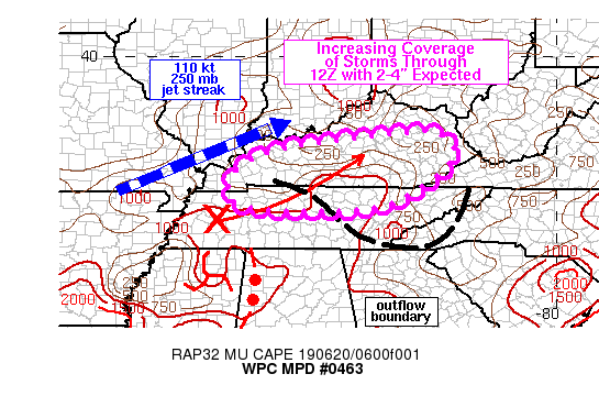
Summary...Repeating and training of thunderstorms may produce
flash flooding across portions of KY into northern TN. 6 hour
rainfall of 2-4 inches can be expected through 13Z, much of which
would fall in about a 3 hour period, in excess of Flash Flood
Guidance.

Discussion...0700Z radar imagery over KY and TN showed scattered
showers and thunderstorms from south-central KY into central and
eastern TN. These showers were fairly weak with peak radar
rainfall estimates of only about 0.5 in/hr per KOHX. The activity
was occurring on the cool side of a weak outflow boundary which
extended from southeastern TN into far northwestern TN at 07Z.
Farther south and west, a forward propagating line of convection
was just entering northwestern AL with a well defined MCV in
northern MS. However, a more subtle circulation was evident in
KNQA reflectivity just northeast of MKL in western TN, associated
with a region of stratiform rain with embedded thunderstorms.

As the weak low level circulation in western TN propagates off
toward the northeast, out ahead of a larger scale shortwave trough
axis to the west, increasing coverage of showers and thunderstorms
are expected through 12Z over northern TN into central and eastern
KY. The right entrance region of a RAP estimated 110 kt jet streak
at 250 mb over southern MO/IL is forecast to move over central KY
between 09-12Z which may also help to support an increased overage
of convection via added divergence aloft. 850 mb VAD wind plots
show 30-40 kt from the WSW in place over central and eastern KY/TN
at 07Z, which is greater than average observed cell motions from
the WSW of 20-30 kt. Given the elevated nature of the showers over
TN/KY, these winds would support training and repeating within an
environment characterized by MLCAPE of 500-1000 J/kg. Flash Flood
Guidance values are as low as 1.5 to 2.5 inches in 3 hours over
northeastern TN into eastern KY. Rainfall rates of 1-2 in/hr seem
probable given the anomalous moisture in place and weak but
sufficient instability.

Otto

ATTN...WFO...JKL...LMK...MEG...MRX...OHX...PAH...

ATTN...RFC...LMRFC...OHRFC...

LAT...LON   38048380 37988303 37498262 36808324 36108454
            36008648 36088799 36448853 37038830 37488752
            37738641
Last Updated: 320 AM EDT Thu Jun 20 2019
|


