| WPC Met Watch |
|
|
Mesoscale Precipitation Discussion: #0543 (2018) |
|
(Issued at 1138 AM EDT Fri Jul 27 2018
) |
|
| MPD Selection |
|
|
|
|
|

Mesoscale Precipitation Discussion 0543
NWS Weather Prediction Center College Park MD
1138 AM EDT Fri Jul 27 2018

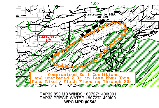
Areas affected...Central to Northeast PA...WV....Western MD...Ext
Northeast VA...

Concerning...Heavy rainfall...Flash flooding likely

Valid 271537Z - 272000Z

SUMMARY...Deep moisture, potential training and compromised
saturated soils likely to produce scattered flash flooding
conditions this afternoon.

DISCUSSION...Recent Goes-16 IR and Visible along with regional
RADAR suite, detect convective destabilization across central WV
along the eastern interface of a narrow but deep moisture
confluence strip.   RAP analysis depicts MLCAPEs to 1000 J/Kg with
Total PWATs up to 1.5" for these cells from Putnam to Lewis
county, WV.  A weak mid-level shortwave/speed max is analyzed
providing the needed mid-level ascent for convective development.
The concern here, beside the complex terrain adding to flash
flooding concern, is proximity to the wave in an fairly
unidirectional flow supports some back-building to compound the
training threat.   IR tops are cooling but fairly shallow
suggesting warm cloud process domination and deceptively efficient
rainfall generation, as supported by observation over 1.15" & 1.6"
near Spencer, WV.

Further east, capping remains in place along eastern WV into south
central PA, where stronger upslope flow in response to the
approaching wave will eventually provide strong
convergence/moisture flux for additional convective development
expected in the next 1-2 hours as the cap finally erodes.  Slow
eastward march of the SW-NE moisture plume should keep extreme
totals below 4", however, the density of the convective
towers/back-building nature will lead lines/patches of 2-3" totals
in short duration over saturated areas of the Blue Ridge into
central and northeast PA.  FFG values may be a bit too low in
reality but even .5-.1"/hour (which should easily be exceeded
without too much training) will produce flash flooding.  As such
scattered pockets of flash flooding is expected/likely through the
afternoon.

GALLINA

ATTN...WFO...BGM...CTP...LWX...PBZ...PHI...RLX...RNK...

ATTN...RFC...MARFC...OHRFC...

LAT...LON   41787601 41167508 39807659 37977862 37748062
            37948201 38448201 39008113 40937806
Last Updated: 1138 AM EDT Fri Jul 27 2018
|


