| WPC Met Watch |
|
|
Mesoscale Precipitation Discussion: #0564 (2019) |
|
(Issued at 1154 AM EDT Mon Jul 08 2019
) |
|
| MPD Selection |
|
|
|
|
|

Mesoscale Precipitation Discussion 0564
NWS Weather Prediction Center College Park MD
1154 AM EDT Mon Jul 08 2019

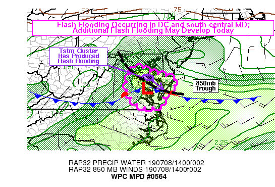
Areas affected...South-Central Maryland, Lower Eastern Shore,
Eastern Virginia

Concerning...Heavy rainfall...Flash flooding likely

Valid 081550Z - 082000Z

Summary...A slow-moving cluster of thunderstorms has produced
widespread flash flooding in the immediate D.C. Metro Area this
morning, and continues to move slowly southeast toward the
southern Chesapeake Bay region. In addition to ongoing runoff and
flooding in areas that have already been hit, additional flooding
is possible. More thunderstorms should develop in eastern Virginia
this afternoon, and these storms could also produce flash
flooding. Rain rates may exceed 2 inches per hour in the strongest
storms.

Discussion...A large, slow-moving convective cluster moved over
the D.C. Metro Area this morning, with DCA measuring 3.3 inches of
rain in an hour. This has an annual exceedance probability of less
than 1 percent, and other mesonet sites have observed similar (3+
inch per hour) rain rates. The convective cluster was beginning to
show some slight downward trends in spatial extent and the
intensity of reflectivity, but radar estimates and surface
observations still showed some rain rates to around 2 in/hr. This
cluster may continue just north of a surface boundary and
eventually affect the southern tip of the Delmarva Peninsula. Over
the next couple hours, the air mass over southern Maryland and the
Delmarva Peninsula should become increasingly stable as stronger
easterly flow develops, focusing the best chances of new
thunderstorm formation into eastern Virginia.

A low level trough extended from near the mouth of Chesapeake Bay
up into northern Virginia, and this coincided with an axis of
maximum PW values. GPS observations between Richmond and Norfolk
sampled PW as high as 2.1 to 2.2 inches this morning, and a 12Z
sounding from Wallops Island measured around 2.3 inch PW. These
values are near or above the 99th percentile. The WAL sounding was
indicative of a deep plume of moisture and a nearly saturated
profile through much of the troposphere. Meanwhile, most of E VA
south of a EZF-WAL line is relatively clear on visible satellite
imagery, with RAP analysis showing widespread SBCAPE values in the
same area around 2000-3000 j/kg. The combination of strong
instability and PW values in excess of 2 inches can yield
significant rainfall rates, and rates in excess of 2-3 in/hr will
be possible in the stronger convection that develops. The RAP also
forecasts increasing ENE flow across the Delmarva and Chesapeake
Bay into the early afternoon, with light northerly flow projected
to continue in interior Virginia. This may set up a more focused
convergence zone over E VA and lead to more concentrated
convective development. If that materializes, the flash flood risk
could be even higher. As it stands, flash flooding will be
possible in E VA this afternoon, particularly if significant
rainfall rates can intersect any of the urban areas, particularly
along the I-64 corridor from Richmond to Norfolk.

Lamers

ATTN...WFO...AKQ...LWX...PHI...

ATTN...RFC...MARFC...SERFC...

LAT...LON   38977731 38937695 38647640 38477554 38077494
            37507565 36827584 36717681 37377764 38307772
Last Updated: 1154 AM EDT Mon Jul 08 2019
|


