| WPC Met Watch |
|
|
Mesoscale Precipitation Discussion: #0582 (2019) |
|
(Issued at 120 PM EDT Thu Jul 11 2019
) |
|
| MPD Selection |
|
|
|
|
|

Mesoscale Precipitation Discussion 0582
NWS Weather Prediction Center College Park MD
120 PM EDT Thu Jul 11 2019

Areas affected...Urban Corridor of I-95 from Northern VA through
Northern NJ

Concerning...Heavy rainfall...Flash flooding likely

Valid 111730Z - 112330Z

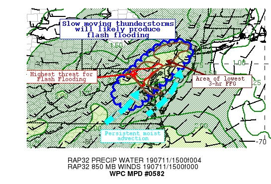
Summary...Increasing coverage of thunderstorms will produce heavy
rain well ahead of a cold front through this evening. These
thunderstorms will likely produce rainfall rates of 2"/hr or more
in an exceptionally moist environment. As storms move slowly this
afternoon, they will produce heavy rain on top of saturated soils,
and low-permeability urban areas. Flash flooding is likely.

Discussion...Radar imagery across the Mid-Atlantic depicts
widespread thunderstorms from Pennsylvania southward into North
Carolina, and eastward into Maryland. These thunderstorms are
developing along/ahead of a pre-frontal trough which will
gradually shift eastward into this evening. At the same time,
convection is blossoming east of the terrain along any weak
surface troughs and convergent boundaries, reflective of the
intense thermodynamics in place.

Recent RAP analyzed PWATs have risen to 1.8-2.0 inches in the
vicinity of the urban I-95 corridor, and may rise towards 2.1
inches later this afternoon. Dew points in the mid 70s are rising
on low-level southerly flow, which is pushing MUCape up over 3000
J/kg along the coastal plain and towards the Potomac Highlands.
This environment will support exceedingly heavy rain, and the
latest HREF neighborhood probabilities are up to 50% for 2"/hr
rain rates into this evening, suggesting the potential for even
higher rates approaching 3"/hr.

As convection continues to increase in coverage and intensity,
thunderstorms are forecast to organize into clusters due to bulk
shear of 25-35 kts. These clusters should move eastward slowly as
noted by layer Corfidi vectors of 5-10 kts, while individual cells
may train within these clusters to the northeast. This setup is
highly favorable for a long duration of heavy rainfall due to
training. Latest HREF exceedance probabilities are up to 80% for
the I-95 corridor between Philadelphia and Washington, D.C., and
there exists a multi-model high-res CAM signature for pockets of
4" of rainfall, if not locally higher. This will occur on top of
areas that have received excessive rainfall over the past week as
noted by departures of 200-400% of normal, and where FFG is as low
0.5"/hr, or 1-2"/3 hrs.

While flash flooding is likely across much of this area, the
highest potential is within the urban corridor from Washington
D.C. to Philadelphia where the model signal is most robust, FFG is
lowest, and HREF probabilities are highest, for excessive
rainfall. Should training occur in this area, flash flooding could
be significant.

Weiss

ATTN...WFO...AKQ...BGM...CTP...LWX...OKX...PHI...

ATTN...RFC...MARFC...NERFC...

LAT...LON   41217488 41147452 40927432 40627433 40087467
            39617521 39297556 38937593 38557640 38127683
            37857710 37647736 37547767 37577799 37687820
            37917851 38117868 38407866 38607856 38977833
            39877745 39847742 40217702 40747639 41107582
            41177542
Last Updated: 120 PM EDT Thu Jul 11 2019
|


