| WPC Met Watch |
|
|
Mesoscale Precipitation Discussion: #0596 (2019) |
|
(Issued at 558 AM EDT Sun Jul 14 2019
) |
|
| MPD Selection |
|
|
|
|
|

Mesoscale Precipitation Discussion 0596
NWS Weather Prediction Center College Park MD
558 AM EDT Sun Jul 14 2019

Areas affected...Mississippi

Concerning...Heavy rainfall...Flash flooding likely

Valid 140955Z - 141555Z

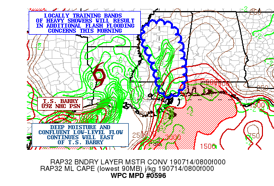
SUMMARY...Narrow training bands of heavy showers will be focusing
across a large area of Mississippi through the mid-morning hours.
Very heavy rainfall rates of near 2 inches/hr will foster concerns
for flash flooding.

DISCUSSION...The latest radar imagery is showing an expansion of
training north/south oriented bands of heavy showers across much
of central MS, with some broken areas of convection seen
developing farther south. Cooling cloud tops have been noted over
the last hour, suggestive of stronger forcing and ultimately
heavier rainfall rates. The convection has been focusing within
modestly confluent low-level southerly flow around the far eastern
semicircle of T.S. Barry's circulation, and is embedded within a
rather strong instability gradient. In fact, there is a rather
substantial pool of moderate instability now pooled up across
southeast MS where MLCAPE values are on the order of 1500 j/kg.
This axis of instability is lifting north gradually with time
given the deeper layer southerly flow over the region.

Moisture remains in abundance this morning with PWATs well over 2
inches, and the latest CIRA-LPW imagery confirming a deep column
of enhanced moisture. High wet-bulb zero levels and a nearly
saturated column will foster warm rain processes for enhanced
rainfall rates that will approach or exceed 2 inches/hr.

The latest HRRR guidance supports as much as 2 to 4 inches of rain
going through 15Z with the training bands of convection, but much
of this will fall in as short as one or two hours. Locally heavier
amounts will be possible. Additional convective bands will tend to
develop through the morning hours and lift northward within the
aforementioned instability gradient.  Given the short-term
rainfall rates over the next few hours, and increasingly sensitive
soil conditions, some areas of flash flooding will be likely.

Orrison

ATTN...WFO...JAN...LIX...MEG...MOB...

ATTN...RFC...LMRFC...SERFC...

LAT...LON   34339022 34288961 34028918 33268887 32398872
            31368862 30678878 30408908 30338945 30478983
            31048997 31859019 32489040 33229079 33759083
            34159067
Last Updated: 558 AM EDT Sun Jul 14 2019
|


