| WPC Met Watch |
|
|
Mesoscale Precipitation Discussion: #0608 (2019) |
|
(Issued at 142 PM EDT Mon Jul 15 2019
) |
|
| MPD Selection |
|
|
|
|
|

Mesoscale Precipitation Discussion 0608
NWS Weather Prediction Center College Park MD
142 PM EDT Mon Jul 15 2019

Areas affected...Southeast Texas

Concerning...Heavy rainfall...Flash flooding likely

Valid 151741Z - 152341Z

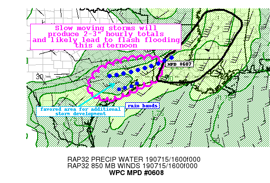
Summary...Convection developing on the southwest flank of an
existing rain band associated with T.D. Barry will be capable of
producing 2-3" hourly totals and will likely lead to flash
flooding.

Discussion...GOES IR imagery showed rapidly cooling cloud tops
associated with convection across portions of southwest Texas.
This activity is developing along the instability and moisture
gradient (SBCAPE from 2000-4000 J/kg and PWs 2.2" to 1.7"). Recent
radar trends from radar estimates of 1.5 to 2.5"/hr rates
developing with the convection, which is slowly moving to nearly
stationary.

The environment will remain conducive for heavy rainfall and flash
flooding through the afternoon hours, with slower storm motions,
ample moisture/instability, parallel mean flow to storm motions,
and focused areas of boundary layer moisture convergence. Given
the deep tropical moisture profiles, efficient rain rates of
2-3"/hr (locally higher possible) will be common and total amounts
through 23z may be in the 4-6" range. Right now the bulk of the
heaviest rain looks to fall north of the Houston metro area, but
some of the hi-res models suggest a south to southwestward
expansion of the heavy rainfall footprint which could impact the
greater Houston area.

Portions of the outlook area have seen heavy rainfall in the last
24 hours and as a result, have lowered flash flood guidance
(locally down to less than 1" in 1-hr). With this in mind, the
locally intense rain rates and potentially longer duration will
likely lead to some instances of flash flooding through the
afternoon.

Taylor

ATTN...WFO...CRP...EWX...HGX...LCH...

ATTN...RFC...LMRFC...WGRFC...

LAT...LON   31049348 30619336 29819365 29649430 29309489
            28969566 28809642 29109730 29659731 30289688
            30629624 30949518 31019416
Last Updated: 142 PM EDT Mon Jul 15 2019
|


