| WPC Met Watch |
|
|
Mesoscale Precipitation Discussion: #0610 (2019) |
|
(Issued at 446 PM EDT Mon Jul 15 2019
) |
|
| MPD Selection |
|
|
|
|
|

Mesoscale Precipitation Discussion 0610
NWS Weather Prediction Center College Park MD
446 PM EDT Mon Jul 15 2019

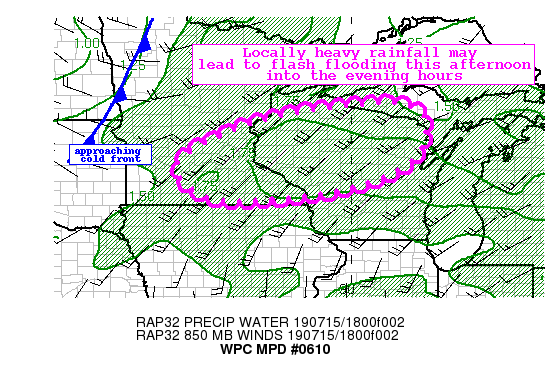
Areas affected...South-Central to Eastern MN...Northern WI

Concerning...Heavy rainfall...Flash flooding possible

Valid 152044Z - 160244Z

Summary...Thunderstorms developing this afternoon into the mid
evening hours will be capable of producing hourly totals as high
as 1.5" and with a few repeating rounds some flash flooding will
be possible.

Discussion...A few clusters of thunderstorms developing this
afternoon associated with a remnant MCV over southern Minnesota
were beginning to grow/upscale per latest IR imagery showing
cooling cloud tops. Current radar mosaic showed the most
concentrated thunderstorms across west-central Wisconsin moving
east/northeastward into north-central Wisconsin. Additional
thunderstorms were developing further north/east across northeast
Wisconsin toward the UP of Michigan border.

This activity is generally working on the greater instability axis
(2500 to 3000 J/kg SBCAPE) within a slightly anomalous PW
environment (1.5 to 1.7" per latest blended TPW product). Overall,
the dynamics/shear are relatively weak in the area which suggests
little storm organization. And the latest RAP points to a
southwest/west mean flow, which is nearly aligned with the
expected storm motions, so some training/repeating rounds will be
possible.

Additional isolated to scattered thunderstorms will develop
along/ahead of an approaching cold front across central Minnesota.
Some of these storms may begin to form west-east line segments and
could train over areas as the storm motions become aligned with
the mean flow.

Hi-res guidance through 01Z offers a variety of solutions and
overall lowers the confidence in how the thunderstorms will
evolve, with the potential for storms to develop ahead of the cold
front to be slower moving then more storms as the main front moves
through. Overall, the potential exists for rain totals of 2-4"
with locally higher amounts 4-5".

Overall, antecedent conditions have been drier than normal in the
last 7-14 days so accordingly the flash flood guidance is 1.5-2.0"
(for 1-hr values) and near 2.5" for 3-hour guidance. It's possible
this could be met or exceeded this evening given the slower storm
motions initially (and higher rates) so some localized flash
flooding will be possible through the mid-evening hours until
instability wanes with loss of daytime heating.

Taylor

ATTN...WFO...ARX...DLH...GRB...MPX...MQT...

ATTN...RFC...NCRFC...

LAT...LON   46408923 46108796 45058806 44368895 43879068
            43679257 43779419 44769492 45929249
Last Updated: 446 PM EDT Mon Jul 15 2019
|


