| WPC Met Watch |
|
|
Mesoscale Precipitation Discussion: #0626 (2018) |
|
(Issued at 242 PM EDT Fri Aug 10 2018
) |
|
| MPD Selection |
|
|
|
|
|

Mesoscale Precipitation Discussion 0626
NWS Weather Prediction Center College Park MD
242 PM EDT Fri Aug 10 2018

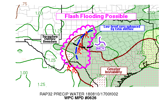
Areas affected...Edwards Plateau and West-Central Texas

Concerning...Heavy rainfall...Flash flooding possible

Valid 101840Z - 102330Z

Summary...Thunderstorms are expected to continue developing this
afternoon from the Big Bend of Texas north into the Edwards
Plateau region and west-central Texas. These storms may be
slow-moving and produce rain rates around 2 in/hr at times. This
could lead to some flash flooding.

Discussion...Convection was beginning to rapidly develop in the
1700-1830Z time frame along a convective outflow boundary, evident
in GOES-16 visible satellite and surface observations. This
outflow boundary stretched from near Sweetwater to near Big Lake,
and surface observations (ASOS + West Texas Mesonet) on either
side of the boundary had winds around 10-15 knots. Thus, the
convergence was fairly strong. A secondary outflow boundary was
possible based on GOES-16 satellite trends, possibly intersecting
the primary outflow near Big Lake, or about 50 miles north of the
I-10 corridor. Areas near this boundary intersection, or just to
the southwest of San Angelo, may be favored for sustained
low-level convergence and a more concentrated area of convection
over the next few hours. This could produce some locally heavy
rainfall; it will be a risk over the entire outlined discussion
area, but may be favored in the area near or just north of I-10.

Thunderstorms may also have a tendency to build south along the
outflow boundary toward the Big Bend of Texas with time. Greater
instability exists further to the south, and those areas have been
undisturbed by previous convection. Deep layer mean winds and
Corfidi vectors are fairly light (less than 10 knots) over most of
the outlined area, so slow-moving storms would be possible even if
the convection builds further south. Additional convection was
developing over the Sierra del Carmen Mountains in far northern
Mexico, just south of the Big Bend of Texas. These were showing a
slight northward drift with time, and thus merging thunderstorm
clusters or colliding outflow boundaries may be a possibility in
several hours closer to the Rio Grande River.

The environment, with moderate instability and precipitable water
values over 1.5 inches, should support locally heavy rainfall with
rain rates approaching 2 in/hr in the stronger and more persistent
thunderstorms. This could lead to flash flooding in some areas.

Lamers

ATTN...WFO...EWX...LUB...MAF...SJT...

ATTN...RFC...WGRFC...

LAT...LON   33230033 32739977 31800041 30780050 29510056
            29620235 30910291 32500173
Last Updated: 242 PM EDT Fri Aug 10 2018
|


