| WPC Met Watch |
|
|
Mesoscale Precipitation Discussion: #0649 (2021) |
|
(Issued at 253 AM EDT Tue Jul 27 2021
) |
|
| MPD Selection |
|
|
|
|
|

Mesoscale Precipitation Discussion 0649
NWS Weather Prediction Center College Park MD
253 AM EDT Tue Jul 27 2021

Areas affected...Far Eastern Minnesota, Northern Wisconsin

Concerning...Heavy rainfall...Flash flooding possible

Valid 270700Z - 271300Z

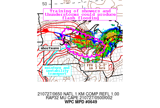
Summary...Training showers and thunderstorms with rain rates
1-1.5"/hr will persist overnight. 1-3" of rainfall with locally
higher amounts is possible in locations that receive multiple
rounds of heavy rain. Flash flooding is possible.

Discussion...Showers and thunderstorms blossoming on the regional
radar mosaic early this morning are occurring along a stationary
front analyzed across northern WI. A shortwave is noted moving
across eastern MN as well, helping to drive local ascent across
the region. While storm motions have been quick so far tonight,
rainfall rates estimated by KPMX WSR-88D have been as high as
1.5"/hr, and several mesonet sites across northern WI have
measured 1-2" of rainfall.

The high-res guidance is struggling with the ongoing convection,
leading to lower than usual confidence in the nocturnal evolution.
However, continued ascent through low-level convergence and ahead
of the shortwave should provide the impetus for a continuation and
expansion of convection overnight. This forcing will act upon an
environment that is favorable for heavy rainfall, with recent GPS
measurements for PW of 1.3-1.5", around the 90th percentile for
the date, and RAP MUCape of 2000-3000 J/kg in a ribbon arcing into
the front from the SW. These robust thermodynamics will continue
to transport into WI overnight as the 850mb LLJ intensifies
towards 30 kts and veers from SW to W, drawing the higher
instability northeastward.

Storm motions are expected to continue to be quick as shown by
0-6km mean winds of 20-30 kts through morning. However, these
winds are generally parallel to the boundary. With some
backbuilding into the better instability likely, this suggests a
good potential for training from WNW to ESE. As rain rates
continue above 1"/hr as shown by the HREF probabilities, this
training could produce 1-3" of rainfall with locally higher
amounts.

Parts of northern WI and eastern MN have seen more than 200% of
normal rainfall the past 7 days leading to FFG that is locally
compromised to 1.5-2"/3hrs. Although the HREF exceedance
probabilities are quite low, less than 20%, it is possible
training of these rain rates could exceed this FFG, leading to
isolated instances of flash flooding.

Weiss

ATTN...WFO...ARX...DLH...GRB...MPX...MQT...

ATTN...RFC...NCRFC...NWC...

LAT...LON   47209261 47079205 46979179 46829145 46709103
            46589063 46539052 46459028 46248976 45748840
            45208733 44838738 44598772 44348841 44288963
            44409054 44689153 45039225 45449272 45839305
            46249321 46619323 47169307
Last Updated: 253 AM EDT Tue Jul 27 2021
|


