| WPC Met Watch |
|
|
Mesoscale Precipitation Discussion: #0664 (2018) |
|
(Issued at 1227 AM EDT Wed Aug 15 2018
) |
|
| MPD Selection |
|
|
|
|
|

Mesoscale Precipitation Discussion 0664
NWS Weather Prediction Center College Park MD
1227 AM EDT Wed Aug 15 2018

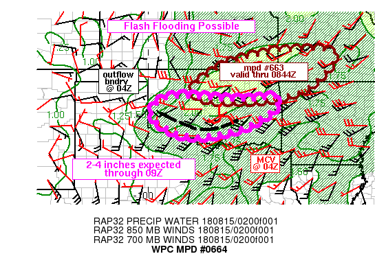
Areas affected...western to central OK

Concerning...Heavy rainfall...Flash flooding possible

Valid 150424Z - 150845Z

SUMMARY...Flash flooding will remain possible across portions of
western and central OK with an additional 2-4 inches of rain
expected through 08Z.

DISCUSSION...Valid at 04Z, a combination of KTLX reflectivity and
surface observations placed an outflow boundary from just south of
PVJ to FSI to just west of HBR to I-40. Convection was most active
across much of west-central OK with KTLX and KFDR estimated rates
ranging from 1.5 to 3+ in/hr. These cells were elevated atop the
outflow produced stable surface layer, with an estimated base
between 850 and 700 mb. Toward the east, weaker convection and
lower rain rates were noted with an MCV entering Pottawatomie
county, possibly due to greater CIN noted on RAP analysis
soundings across southeastern OK.

The elevated nature of the convection in western OK is likely to
experience some brief periods of training given similar 850-300 mb
and 700 mb wind direction, but with 700 mb flow slightly stronger
and slightly more backed than the layer-mean wind, allowing for
slow southward propagation with time. 850 mb flow across
southwestern OK was 25-30 kt via the KFDR VAD wind plot, which
will continue to overrun the southward sagging outflow boundary in
western OK. ML and MUCAPE values via the 03Z SPC mesoanalysis page
indicate 1000-2000 J/kg is present from the western Red River
Valley into west-central OK which should allow for another few
hours of heavy rainfall. An additional 2-4 inches of rain is
expected with may overlap with more sensitive regions given recent
rainfall, allowing for possible flash flooding.

Otto

ATTN...WFO...ICT...LZK...OUN...SGF...TSA...

ATTN...RFC...ABRFC...LMRFC...MBRFC...

LAT...LON   37779442 37669224 36329335 35789494 35749742
            36189818 36879732 37309655
35899834 35779725 35739596 35799529 35859462
            35679457 35319483 34939541 34519636 34229819
            34679939 35059986 35529971 35769932
Last Updated: 1227 AM EDT Wed Aug 15 2018
|


