| WPC Met Watch |
|
|
Mesoscale Precipitation Discussion: #0673 (2018) |
|
(Issued at 429 AM EDT Thu Aug 16 2018
) |
|
| MPD Selection |
|
|
|
|
|

Mesoscale Precipitation Discussion 0673
NWS Weather Prediction Center College Park MD
429 AM EDT Thu Aug 16 2018

Areas affected...Desert Regions of Wrn Arizona and SErn California

Concerning...Heavy rainfall...Flash flooding possible

Valid 160828Z - 161230Z

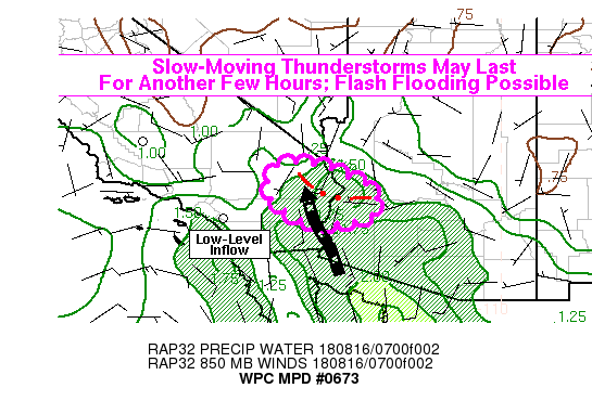
Summary...Slow-moving thunderstorms may persist for another few
hours in the Lower Colorado River region near the Arizona and
California border. The storms will be capable of producing 1-2
in/hr rain rates and flash flooding.

Discussion...Convection began to grow in coverage and organization
over southern Mohave County, AZ around 06Z, and now appear to have
established a weak cold pool in that same area. KHII reported a
T/Td of 81/64 at 08Z, compared to 97/57 just a couple hours ago.
RAP analysis showed a channel of low-level inflow up the Colorado
River valley, around 10-15 knots in the 925-850mb layer, and the
ongoing convection was situated on the nose of this inflow. The
KYUX radar VWP even had the 925mb winds at 15-20 knots out of the
south. This is likely aiding in focusing and sustaining an area of
convection at this time of the diurnal cycle, usually after the
point when monsoonal convection diminishes. These inflow winds
appear likely to be sustained through at least 11-12Z, so it is
possible convection will be able to maintain itself in some
fashion through that same time frame. However, the convection
recently has become slightly less disorganized, likely as
thunderstorm outflow has pushed out a bit further from the
stronger updrafts. Nevertheless, sustained ascent along the
outflow boundary should provide the potential for renewed cell
growth over the next couple hours, and these storms may be
slow-moving. Additionally, some ascent of the southerly inflow
over the near-surface cold pool could sustain some elevated
convection to the north, over areas that have already received
locally heavy rainfall. These factors should contribute to a
continued flash flood threat over the next few hours in the desert
regions near the Arizona-California border.

Lamers

ATTN...WFO...FGZ...PSR...VEF...

ATTN...RFC...CBRFC...CNRFC...

LAT...LON   34921494 34581401 34321344 33921326 33571347
            33341461 33581546 34091607 34851593
Last Updated: 429 AM EDT Thu Aug 16 2018
|


