| WPC Met Watch |
|
|
Mesoscale Precipitation Discussion: #0680 (2018) |
|
(Issued at 1205 AM EDT Fri Aug 17 2018
) |
|
| MPD Selection |
|
|
|
|
|

Mesoscale Precipitation Discussion 0680
NWS Weather Prediction Center College Park MD
1205 AM EDT Fri Aug 17 2018

Areas affected...Central Illinois, Northeast Missouri

Concerning...Heavy rainfall...Flash flooding possible

Valid 170405Z - 171000Z

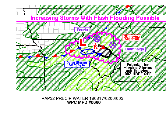
Summary...Thunderstorms will become more numerous over central
Illinois overnight, and several rounds of storms may affect
individual locations. The repeated rounds of storms should lead to
locally heavy rainfall, with the associated possibility of flash
flooding. The highest chance of flash flooding appears to be in
the Springfield, IL to Effingham, IL corridor. Rain rates to
around 2 in/hr will be possible.

Discussion...Convection was beginning to increase in coverage on
the southeast flank of an upper level low, very clear on GOES-16
water vapor channels over south-central Illinois. The cooling
cloud tops on IR channels, and increasing lightning activity, was
particularly noted along and ahead of a meandering
quasi-stationary front from north-central Missouri into western
and northern Illinois (with a surface low analyzed in west-central
Illinois). Precipitable water values were approaching 2 inches in
the region per CIRA blended TPW product and RAP analysis, and this
should create a favorable environment for heavy rain rates with
any convection that develops. There was a reasonably strong signal
in the hi-res models from the 00Z cycle for heavy rainfall in
central Illinois. The 00Z HREF had around a 50 percent chance of 3
inches of rain between Springfield and Effingham. This also
happened to be an area with likely storm mergers based on KILX
radar trends. An organized supercell had been pushing southeast
and was passing near Springfield as of 04Z. Meanwhile, a large
area of convection was developing to the WSW (south of I-72) and
was lifting ENE, setting up likely storm mergers and a broad
coalescing of thunderstorms in or very near the same area
highlighted by the HREF. Therefore, this may be a favored region
for flash flooding, given the fairly good hi-res model agreement
in addition to the observational data trends.

Elsewhere across the region, from central Illinois into northeast
Missouri, sufficient moisture and instability (MLCAPE 1500+) exist
to support organized convection with locally heavy rainfall. There
is not a dominant focusing mechanism to channel the convection
into a particular area, other than the aforementioned small
portion of central Illinois, and thus other areas of locally heavy
rainfall would likely result from somewhat random cell mergers.
However, flash flooding cannot be ruled out in these cases.

Heavy rainfall in excess of 3 inches appears likely in some parts
of central Illinois, and localized significant totals in excess of
5 inches would be possible if cell mergers sustain favorable
training for several hours.

Lamers

ATTN...WFO...DVN...EAX...ILX...LOT...LSX...PAH...

ATTN...RFC...MBRFC...NCRFC...OHRFC...

LAT...LON   41068930 40828834 40308768 39288772 38708798
            38568872 39018981 39119049 39069136 39379235
            39869247 40459090 40809012
Last Updated: 1205 AM EDT Fri Aug 17 2018
|


