| WPC Met Watch |
|
|
Mesoscale Precipitation Discussion: #0693 (2022) |
|
(Issued at 157 PM EDT Sat Aug 06 2022
) |
|
| MPD Selection |
|
|
|
|
|

Mesoscale Precipitation Discussion 0693
NWS Weather Prediction Center College Park MD
157 PM EDT Sat Aug 06 2022

Areas affected...eastern AZ, southern CO, much of NM

Concerning...Heavy rainfall...Flash flooding possible

Valid 061800Z - 070000Z

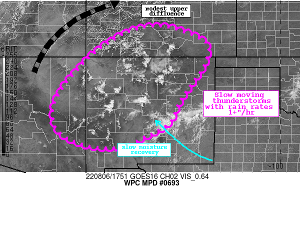
Summary...Scattered slow moving thunderstorms will develop across
the Four Corners this aftn with rain rates increasing to 1+"/hr.
Flash flooding is possible, especially where any storm moves over
recent burn scars.

Discussion...The GOES-E visible imagery this aftn shows deepening
Cu developing across much of the terrain of northern and western
NM. These storms are developing along the western periphery of the
monsoon ridge, and in response to subtle upper diffluence focused
just north of the region. PWs as measured by GPS are around 0.8 to
1.0 inches, which is around the 75th percentile, but are expected
to continue to increase into the evening as low-level flow surges
out of the Gulf of Mexico and up the Rio Grande Valley. SBCAPE
according to the SPC RAP analysis is 1000-2000 J/kg, and the
overlap of this instability/moisture is helping to fuel these
developing thunderstorms.

As storms continue to expand and intensify, rain rates will likely
exceed 1"/hr as shown by the HREF neighborhood probabilities as
well as accumulated precip fields from the UA WRF and sub-hourly
HRRR. Storms producing this rainfall will likely be very slow
moving as progged by 0-6km mean winds, with motion generally
rotating anti-cyclonically around the ridge from the east or
south. Additionally, storm motions could be chaotic due to
boundary collisions and storm mergers in the pulse environment,
with near zero motion at times the next few hours where storms
become tied to upwind terrain features. These slow or chaotic
motions of the impressive rain rates will could result in 1-2" of
rainfall in less than 1 hour, with the HREF probabilities
suggesting a low-end threat for total rainfall of 2-3" in isolated
areas.

The active monsoon has been ongoing for many weeks now, and
0-100cm soil moisture according to NASA SPoRT is above the 98th
percentile in many locations due to 30-day rainfall that is
generally 200-400% of normal. 1-hr FFG continues to be quite low,
0.75-1"/1hr, and even lower across burn scars or sensitive
terrain. The HREF indicates a 20-25% chance of exceedance of this
1-hr FFG, but the greatest risk will remain across the more
sensitive terrain and burn scars through this evening.


Weiss

ATTN...WFO...ABQ...EPZ...FGZ...GJT...PSR...PUB...TWC...

ATTN...RFC...ABRFC...CBRFC...WGRFC...NWC...

LAT...LON   38410613 38360512 37890383 37440335 36590358
            35800411 34900473 33940516 33360614 32840740
            32820864 33070958 33411021 33851052 34501061
            35351027 36080972 37290852 38100719
Last Updated: 157 PM EDT Sat Aug 06 2022
|


