| WPC Met Watch |
|
|
Mesoscale Precipitation Discussion: #0728 |
|
(Issued at 154 PM EDT Thu Jul 17 2025
) |
|
| MPD Selection |
|
|
|
|
|

Mesoscale Precipitation Discussion 0728
NWS Weather Prediction Center College Park MD
154 PM EDT Thu Jul 17 2025

Areas affected...Southwest

Concerning...Heavy rainfall...Flash flooding likely

Valid 171753Z - 172353Z

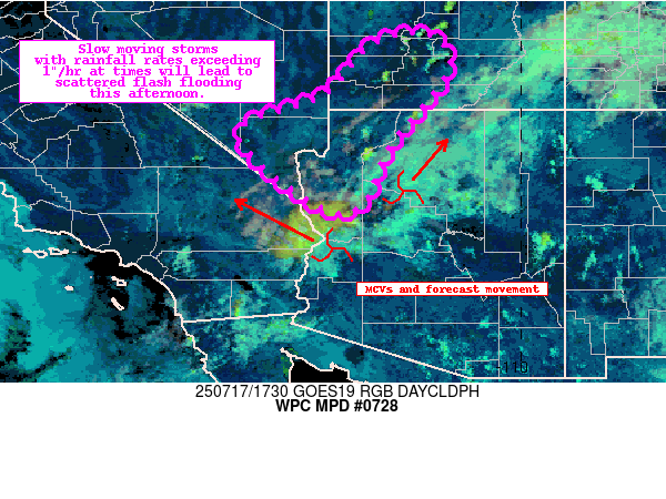
Summary...Convective initiation is underway over portions of
Northwest Arizona and Southern Utah. Expanding coverage of slow
moving storms with max rainfall rates exceeding 1"/hr will lead to
scattered flash flooding this afternoon.

Discussion...Recent GOES Day Cloud Phase RGB and LightningCast
data depict the first signs of glaciation and lightning activity
in a handful of storms developing over Northwest Arizona and
Southern Utah. These cells are forming on the warm side of a
differential heating zone, downstream of a pair of compact MCVs
which have generally been lifting north this morning.

Recent mesoanalysis data on the warm side of the boundary
highlights an increasingly unstable, uncapped atmosphere
characterized by 1000-1500 J/kg of SBCAPE to support expanding
cell coverage and intensity in the presence of the upstream MCVs,
heating boundary, and terrain. Over the next several hours, short
term RAP forecasts suggest upwards of 2000 J/kg of SBCAPE (over
1000 J/kg MLCAPE) could materialize -- which is noteworthy as
impactful flash flood events in the region tend to feature at
least 1000 J/kg of SBCAPE. Overlapping this buoyancy is a steady
influx of precipitable water in the 1-1.7" range, well over the
90th percentile for much of the region. In all, this will support
efficient, slow moving updrafts (10 kt storm motions) with hourly
rainfall rates exceeding 1"/hr -- as suggested by the 12z HREF.

As additional storms form this afternoon, both the HREF and REFS
neighborhood probabilities depict a 30-70% chance of 6 HR QPF
exceeding the 10 year ARI in the highlighted area, with embedded
20-30% probabilities of 100 year ARI exceedance focused over
Northwest Arizona and Southwest Utah. This suggests that scattered
instances of flash flooding are likely this afternoon as this
activity expands in coverage and intensity. Considerable to
significant flash flooding impacts are possible, especially over
sensitive burn scars, dry washes, and slot canyons.

Asherman

ATTN...WFO...FGZ...SLC...VEF...

ATTN...RFC...RSA...STR...NWC...

LAT...LON   38581192 37831152 36161280 35061330 34941420
            36501592 37321410 38371312
Download in GIS format: Shapefile
| KML
Last Updated: 154 PM EDT Thu Jul 17 2025
|


