| WPC Met Watch |
|
|
Mesoscale Precipitation Discussion: #0774 (2020) |
|
(Issued at 1007 AM EDT Sun Sep 20 2020
) |
|
| MPD Selection |
|
|
|
|
|

Mesoscale Precipitation Discussion 0774
NWS Weather Prediction Center College Park MD
1007 AM EDT Sun Sep 20 2020

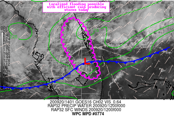
Areas affected...East Coast Florida

Concerning...Heavy rainfall...Flash flooding possible

Valid 201406Z - 202006Z

Summary...Localized flooding will be possible today with isolated
to scattered thunderstorms capable of producing efficient, intense
rain rates. Urban and other sensitive areas will be most
susceptible to flooding.

Discussion...Strong onshore flow over the east-central Florida
coast is evident this morning with a weak surface low now dropping
south the eastern Florida coast. Regional radar from MLB and JAX
show scattered thunderstorms that recently produced hourly totals
greater than 1" per mesonet observations. The combination of
strong low level flow (30 kts per recent analysis) and higher than
normal precipitable water values (2.2 to 2.4 inches) with
increasing instability due to solar insolation will promote the
development of rain efficient thunderstorms into the afternoon
hours. Mean wind flow is rather weak but also out of the northeast
and parallel to the expected storm motion. This will support some
possibility of training or backbuilding.

The most recent HREF probabilities support hourly totals in excess
of 1" at times with some signal approaching 2" this afternoon.
6-hr totals from the various hires guidance supports rain totals
through 21Z of 2-4" though there is some potential for
local/isolated higher amounts 3-5". If backbuilding or training
storms occur over urban or other sensitive areas, then some
localized flooding will be possible.

Taylor


ATTN...WFO...JAX...MLB...TBW...

ATTN...RFC...SERFC...NWC...

LAT...LON   29288140 29278103 28798069 28158049 27628035
            27228019 26988036 27208088 27948136 28638162
Last Updated: 1007 AM EDT Sun Sep 20 2020
|


