| WPC Met Watch |
|
|
Mesoscale Precipitation Discussion: #0775 (2020) |
|
(Issued at 515 PM EDT Sun Sep 20 2020
) |
|
| MPD Selection |
|
|
|
|
|

Mesoscale Precipitation Discussion 0775
NWS Weather Prediction Center College Park MD
515 PM EDT Sun Sep 20 2020

Areas affected...Central FL

Concerning...Heavy rainfall...Flash flooding possible

Valid 202115Z - 210300Z

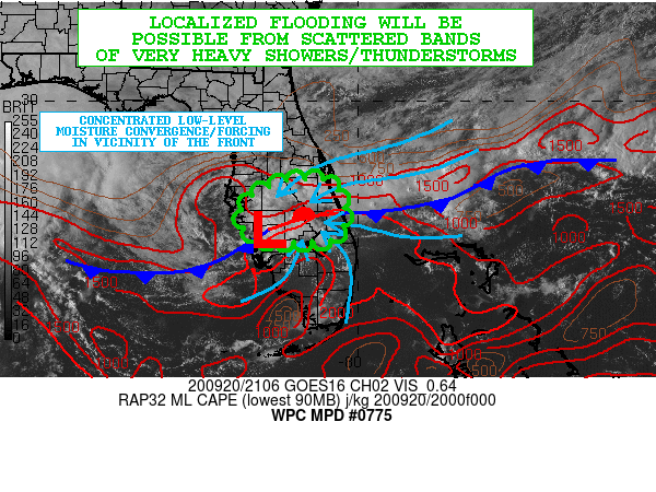
SUMMARY...Scattered bands of very heavy showers and thunderstorms
may result in at least some localized flooding concerns going
through the evening hours.

DISCUSSION...The afternoon GOES-16 visible satellite imagery,
along with surface observations and radar, shows a rather
well-defined area of low pressure west of Lake Okeechobee that is
focused along a frontal zone that is gradually settling down to
the south. Meanwhile, there is a rather well-organized narrow band
of convection seen wrapping around the northern and eastern flanks
of the low center as the low moves generally off to the west.
Elsewhere, additional clusters of cold-topped convection are seen
west of Melbourne and also over the offshore Atlantic waters east
of Melbourne.

The low center and proximity of the front are collectively
fostering an axis of rather strong low-level moisture convergence
and forcing, which in part is being aided by a strong surge of
northeasterly low-level flow dropping down across central and
northern FL. PWs across the region are very high and indicative of
a tropical airmass with values of 2.3 to 2.5 inches, and the
airmass pooled along the front is moderately unstable with MLCAPE
values of 2000+ j/kg.

Rainfall rates with the associated shower and thunderstorm
activity are consequently very high given the favorable
thermodynamic environment, and even though the convection coming
into the east coast of FL has been quite progressive, there have
been some very efficient rainfall processes resulting in hourly
rainfall amounts of 1.5 to 2 inches. Meanwhile, with the
aforementioned convective band closer into the low center, there
has been some training of this activity over the same area which
has already resulted in some dual-pol QPE amounts of 3 to 4 inches
over the last couple of hours.

Overall, the experimental HRRR appears to have a reasonably good
handle of the ongoing activity, and this guidance tends to support
some additional rainfall amounts of 3 to 4+ inches going through
03Z (11pm EDT). In time the front should settle further south
which will generally favor the convection focusing farther south
as well going into the overnight hours. The gradual loss of
daytime heating/instability should at least allow for the coverage
of convection to also decrease some after 00Z.

Nevertheless, given such high short-term rainfall rate potential
and also localized training concerns, some pockets of flooding
cannot be ruled out.

Orrison

ATTN...WFO...MFL...MLB...TBW...

ATTN...RFC...SERFC...NWC...

LAT...LON   28278067 27758031 27308033 27018059 26998107
            26978190 27158235 27498251 27908234 28258160
Last Updated: 514 PM EDT Sun Sep 20 2020
|


