| WPC Met Watch |
|
|
Mesoscale Precipitation Discussion: #0776 (2020) |
|
(Issued at 713 PM EDT Sun Sep 20 2020
) |
|
| MPD Selection |
|
|
|
|
|

Mesoscale Precipitation Discussion 0776
NWS Weather Prediction Center College Park MD
713 PM EDT Sun Sep 20 2020

Areas affected...Southeast LA

Concerning...Heavy rainfall...Flash flooding possible

Valid 202313Z - 210500Z

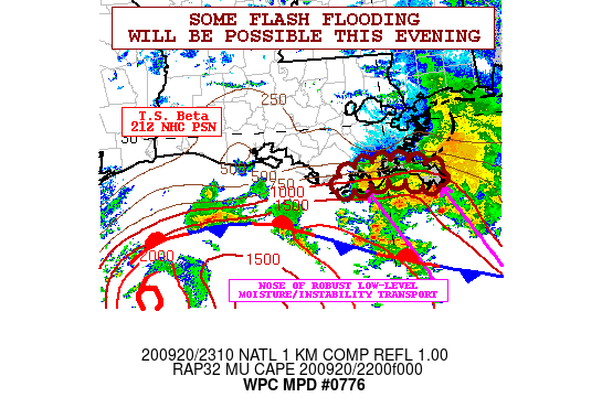
SUMMARY...Some localized flash flooding from slow-moving and very
heavy showers and thunderstorms will be possible this evening.

DISCUSSION...The latest radar imagery shows a cluster of
slow-moving, but very heavy showers and thunderstorms offshore of
the southeast LA coastline. The convection has been focusing
within the relatively strong low-level southeast flow pattern
around the eastern flank of T.S. Beta, and with a correspondingly
favorable degree of moisture and instability transport aimed
toward the immediate coastal areas of southeast LA.

A strong instability gradient is noted over much of south-central
to southeast LA including the offshore waters of the northern Gulf
of Mexico. The gradient is being facilitated by a quasi-stationary
frontal zone draped around the north side of T.S. Beta and
extending east across the north-central Gulf of Mexico. Much of
the convection is embedded within this gradient and is being
supported to some degree by the isentropic ascent being fostered
by the southeast flow overrunning the front.

The latest HRRR and experimental HRRR solutions suggest
slow-moving convection attempting to become highly concentrated
along the southeast LA coast, and suggest an additional 3 to 5+
inches of rain will be possible going through the evening hours
although they disagree on the exact placement of this. The latest
radar trends would suggest the greatest potential setting up over
Plaquemines parish.

Already these areas have been quite wet over the last 48 hours,
and with the additional rainfall potential, some localized areas
of flash flooding, or at least areal flooding will be possible.

Orrison

ATTN...WFO...LIX...

ATTN...RFC...LMRFC...NWC...

LAT...LON   29479010 29418952 29328925 29198903 29038914
            29038937 29148969 29178997 29079048 29059081
            29229086 29389054
Last Updated: 713 PM EDT Sun Sep 20 2020
|


