| WPC Met Watch |
|
|
Mesoscale Precipitation Discussion: #0795 (2020) |
|
(Issued at 526 AM EDT Fri Sep 25 2020
) |
|
| MPD Selection |
|
|
|
|
|

Mesoscale Precipitation Discussion 0795...Corrected
NWS Weather Prediction Center College Park MD
526 AM EDT Fri Sep 25 2020

Corrected for Jet Level/Strength in Discussion/Graphic.

Areas affected...Western Washington...Northwest Oregon...

Concerning...Heavy rainfall

Valid 250820Z - 251500Z

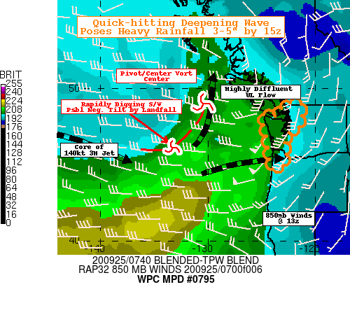
SUMMARY...Fast moving slug of moisture at nose of deep moisture
plume along with strong dynamic forcing pose quick-hitting heavy
rainfall (3-5") threat across the Olympic Range into the Northern
Cascades through daybreak.

DISCUSSION...CIRA Layered PW shows nose of deep, laminar moisture
plume nosing across 130W at this time, with the 850-7H nose
preceding ever so slightly the surface to 850mb and even upper
level layers.  Core moisture is running about 1.5" total though
that core is not likely to reach the NW coast until later morning,
as dynamic forcing will flux the moisture northward along/ahead of
strengthening height-falls.   GOES-WV suite denotes this very well
with lead stronger shortwave near 49N130W starting to anchor and
pivot with strong broad (about 75-90 degrees) of diffluent flow.
The core of the 100kt 3H jet is anticyclonically arched west of
140W and is digging to sharpen the base of the trailing
shortwave/trof axis.  This accelerating/amplifying inflection will
rapidly increase low level cyclonic response and low level flow.

Strong Southwesterly flow with rapidly increase from 30kts at
850mb to around 50-60kts near 12-13z, providing that strong
isentropic/orographic ascent across the Olympic range.  But given
positive to neutral to possibly negative tilting of the inflection
of the trof in diffluent flow will rapidly increase divergence
aloft and support very strong vertical ascent.  This will be
maximized with as sharp veering convergence flow to come ashore in
the 13-14z time frame.  Combined with total PWATs increasing from
1.25 to near 1.5", flux convergence is likely to support .75"/hr
rates along this north-northeast to south-southwest axis, this
without thermal instability fields with less than 100 J/kg
forecast in this warm conveyor belt surge.   Adding favorable SW
to W orographic ascent in the Olympics at 50-60kts may add .5"/hr
rates as suggested by the broad suite of Hi-Res CAMs including the
RAP/HRRR.   While this area is not typically prone to flash
flooding (due to limited infrastructure in the frequently
inundated flow channels), rapid rises should be expected though
due to 3-5" totals across the Olympics by 15z (1.5-2.5" for lower
coastal ranges of SW WA into NW OR).  HREF Probabilities are
running about 80-90% of 3" exceedance by 15z providing solid
confidence in timing/rainfall totals.  Due to the orientation of
the forcing, the wave will also start to affect the Northern WA
Cascade Range by 15z as well with the start of .5-.75"/hr rates,
with HREF 2" totals reaching 60-75% by 15z as well.

ATTN...WFO...PQR...SEW...

ATTN...RFC...NWRFC...NWC...

LAT...LON   49112206 49032130 48172135 47472176 47382234
            46852289 45812275 45062308 44902379 45162420
            46212429 47222453 47882479 48392496 48422420
            48282367 48392337 48622325 48942310 49082270
Last Updated: 526 AM EDT Fri Sep 25 2020
|


