| WPC Met Watch |
|
|
Mesoscale Precipitation Discussion: #0803 (2020) |
|
(Issued at 1234 AM EDT Wed Sep 30 2020
) |
|
| MPD Selection |
|
|
|
|
|

Mesoscale Precipitation Discussion 0803
NWS Weather Prediction Center College Park MD
1234 AM EDT Wed Sep 30 2020

Areas affected...Mid-Atlantic Coast into New England...

Concerning...Heavy rainfall

Valid 300435Z - 301200Z

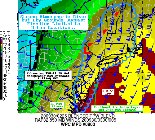
SUMMARY...Anomalous synoptic forcing is driving extreme moisture
flux transport across the region.  Rain-rates & totals may not be
high enough to exceed higher FFG values (dry ground conditions)
but quick rises and localized flooding may occur, particularly in
steeper south-facing orography and urban centers with poor
drainage.

DISCUSSION...Highly dynamic/deep latitude trof is starting to lift
northeast and set up a very strong atmospheric river given deep
subtropical moisture stream along/ahead of it.   GOES-WV suite
depicts strong 150+ kt 3H jet across the Central Appalachians with
increasing anticyclonic curving across New York as the base of the
trof sharpens.  Vorticity Analysis depicts 32-35 units starting
lift northeast with best inflection starting to occur across
Central VA.  This is providing an elongated but rapidly deepening
surface/boundary layer pattern that is starting to back low level
flow toward the Mid-Atlantic into the Southern New England.  In
addition, low level flow is expected to increase at 85H from the
30-40kt flow noted in the VWP toward 60-65kts by 09z across New
England.  This back/strengthen boundary layer flow is also
along/just ahead of the aforementioned inflection entering the
Delmarva.  CIRA LPW suite denotes that this is also the
intersection of the deep lower level moisture axis/warm conveyor
(along the eastern Seaboard) and the mid-level moisture stream at
85-5H), leading to increased deep layered moisture totals of
2-2.25".  Combining the wind acceleration and moisture
availability yields IVT values starting to reach 1250 kg/m/s which
will eventually reach 1500 kg/m/s toward 12z into New England. The
strength of this flow/moisture flux is near climatological (30yr)
return rates and Maximum PW and IVT values for this time of year.

At this time, though, the deepening moisture stream confluence has
flattened lapse rates aloft, so instability has waned particularly
north of 40N.  However, slant-wise acceleration given the
deepening of the low-level cyclone should support increased
rain-fall efficiency (flux convg) and perhaps continue to enhance
embedded convective-like elements across eastern NJ into S New
England from 06-09z (and downstream into the central/northern New
England terrain afterward).  These narrow convective elements will
have the capability to generate .75-1.25" totals over a
short-duration (about 1 hour) within the broader longer duration
shield precip field of of .1-.3"/hr totals.  This would be
consistent with current observation trends from the Eastern VA
Necks into SE VA where 1-1.5"/hr rates have been observed given
the reducing mid-level instability avialable over SE VA/S
Delmarva.

Unlike the atmospheric river setups along the West Coast, the
duration of the heavy rainfall, orientation of warm, moisture rich
conveyor belt will advance eastward fairly quickly limiting the
duration of heavy rainfall.  Current ground conditions suggest
this will be more welcoming than a flooding concern given the
drought, very dry ground conditions present over New England,
where dry anomalies are running about 10-25% of normal for the
month and overall summer.  Still, sub-hourly totals of 1" could
still pose a risk to rapid rises along creeks/rivers but likely
stay within the normal banks, but urban-style flooding remains a
risk through the morning.   Any out of bank, flash flooding
concerns would be limited to the Delmarva/S NJ where ground
conditions are more normal or even slightly above normal over the
last 30 days (per AHPS).  As such, this discussion is written as a
Heavy Rainfall/Atmospheric River style MPD as flash flooding is
not expected unless in prone urban centers.

Gallina

ATTN...WFO...AKQ...ALY...BGM...BOX...BTV...GYX...OKX...PHI...

ATTN...RFC...MARFC...NERFC...NWC...

LAT...LON   44627157 44337082 42517086 41427117 40757215
            40267373 37987505 37137577 37367610 38077613
            38767629 39677592 40657544 41637551 42357522
            42817461 43327380 43857357 44377300
Last Updated: 1234 AM EDT Wed Sep 30 2020
|


