| WPC Met Watch |
|
|
Mesoscale Precipitation Discussion: #0815 (2020) |
|
(Issued at 446 PM EDT Fri Oct 09 2020
) |
|
| MPD Selection |
|
|
|
|
|

Mesoscale Precipitation Discussion 0815
NWS Weather Prediction Center College Park MD
446 PM EDT Fri Oct 09 2020

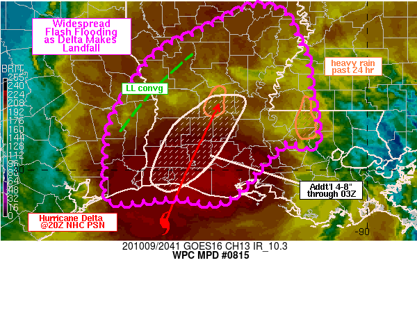
Areas affected...eastern TX...southwestern to northeastern LA

Concerning...Heavy rainfall...Flash flooding likely

Valid 092045Z - 100245Z

SUMMARY...The core of the heaviest rain associated with Hurricane
Delta will move inland across southwestern into central LA over
the next 3-6 hours along with likely flash flooding. Some flash
flooding could be significant given an additional 4-8 inches
through 03Z, overlapping with heavy rain which fell over the past
24 hours near Alexandria.

DISCUSSION...NHC estimated Hurricane Delta to be roughly 50 miles
south of Cameron, LA at 20Z, with a movement off toward the NNE at
12 kt. GOES East 10.3 micron imagery showed the coldest cloud tops
over the TX and LA coasts with values ranging between -75 C and
-90 C. This region of coldest cloud tops, stretching from near
Winnie, TX to Lafayette, LA, has been associated with observed
rain rates between 0.5 and 1.5 in/hr ending at 20Z. KHGX and KPOE
reflectivity indicated the northern eyewall of Delta was just
starting to make landfall into Cameron and Vermilion parishes.

The current track and speed of Delta will take its center toward
Alexandria through 06Z. Expect rainfall rates with, and just north
of, Delta's eyewall to be in the 2-3 in/hr range. Rainfall rates
up to 1-2 in/hr can be expected to the immediate west and east of
Delta's inner core. Delta's forecast track places the highest
rainfall over the next 6 hours along a swath that overlaps with a
region of heavy rainfall (4-6 inches) which fell over the past 24
hours just southwest of Alexandria. Widespread flash flooding,
some of which could be significant, is expected into the early
overnight hours as Delta moves inland across southwest to central
LA. Some local enhancement to rainfall will also be possible from
southwest to northeast across the central TX/LA border in
association with a forecast low level convergence axis expected to
set up between 00Z-03Z.

Farther east, just northeast of Baton Rouge, 5 to 10 inches of
rain was reported through this morning. While this area is
certainly sensitive to flash flooding from added rainfall, it
appears the track and heaviest rainfall from Delta will pass west
of the 5 to 10 inch area, with additional forecast rainfall in the
1-2 inch range in the vicinity of Baton Rouge.

Otto

ATTN...WFO...HGX...JAN...LCH...LIX...SHV...

ATTN...RFC...LMRFC...WGRFC...NWC...

LAT...LON   32729171 32649142 32429127 32169117 32049108
            31719100 31489098 31279096 30989089 30719087
            30509083 30389100 30479137 30199168 29479241
            29559321 29479426 29939437 30809427 31619379
            32019344 32279291 32479250 32719203
Last Updated: 446 PM EDT Fri Oct 09 2020
|


