| WPC Met Watch |
|
|
Mesoscale Precipitation Discussion: #0865 (2018) |
|
(Issued at 1240 PM EDT Wed Sep 19 2018
) |
|
| MPD Selection |
|
|
|
|
|

Mesoscale Precipitation Discussion 0865
NWS Weather Prediction Center College Park MD
1240 PM EDT Wed Sep 19 2018

Areas affected...Southern AZ

Concerning...Heavy rainfall...Flash flooding likely

Valid 191640Z - 192240Z

Summary...Moisture associated with the northward advance of T.D.
Nineteen-E will be arriving across especially southern AZ today.
Heavy showers and thunderstorms are expected, and some flash
flooding will be likely.

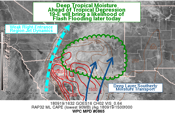
Discussion...Already the latest GOES-16 satellite imagery shows an
extensive northward advance of moisture and cloudiness into the
Southwest U.S. out ahead of newly formed T.D. Nineteen-E over the
Gulf of CA. The T.D. is expected to lift to the north through
today and this will bring an increasing surge of tropical moisture
into especially southern AZ. The latest AMSU microwave data
already shows PWATS well in excess of 2.25 inches just south of
the AZ border and down over northwest mainland Mexico.

The latest radar imagery is already showing an arc of showers and
thunderstorms impacting portions of Yuma, Pima and Maricopa
counties with some localized rainfall rates of 0.50 to 0.75
inches/hr. However, over the next several hours, the latest
consensus of hires model guidance strongly suggests areas of
south-central to southeast AZ will begin to see an increase in
convective coverage and organization as diurnal heating
destabilizes the boundary layer further and works in tandem with
the deep layer moisture transport from the south around the
northern flank of Nineteen-E. The latest upper air analysis is
also showing some weak right-entrance region jet dynamics over the
region which will tend to provide at least some very modest deep
layer forcing for a more organized convective threat considering
the improving thermodynamics.

The latest consensus of the 12Z HREF model suite along with
consecutive runs of the HRRR strongly support rainfall rates that
may exceed 2 inches/hr this afternoon as convection intensifies,
with storm totals by 22Z of as much as 3 to 5 inches. Given the
highly efficient deep layer column of tropical moisture arriving,
these amounts seem quite plausible. Flash flooding will be likely
with these anticipated totals, and especially near any areas of
higher terrain and the area dry washes. Will continue to monitor.

Orrison

ATTN...WFO...FGZ...PSR...TWC...

ATTN...RFC...CBRFC...

LAT...LON   34511052 34180950 33170904 31980910 31430957
            31251044 31391146 31661244 32001350 32521395
            33041390 33561369 34121282 34451160
Last Updated: 1240 PM EDT Wed Sep 19 2018
|


