| WPC Met Watch |
|
|
Mesoscale Precipitation Discussion: #0866 (2020) |
|
(Issued at 249 PM EST Fri Nov 27 2020
) |
|
| MPD Selection |
|
|
|
|
|

Mesoscale Precipitation Discussion 0866
NWS Weather Prediction Center College Park MD
249 PM EST Fri Nov 27 2020

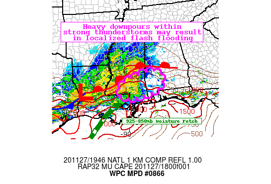
Areas affected...Eastern LA... Southern MS... Southwest AL

Concerning...Heavy rainfall...Flash flooding possible

Valid 271948Z - 280048Z

SUMMARY... Precipitation shield with embedded heavy thunderstorms
to track towards southern MS and AL this afternoon. Rainfall rates
around 2" per hour could occur within the strongest areas of
convection and pose a threat for flash flooding.

DISCUSSION...Doppler radar shows a swath of moderate-to-heavy rain
stretching from southeast TX to southwest MS with stronger cells
embedded within the area of precipitation. The environment remains
favorable for fostering periods of rain as the region lies beneath
the right-entrance region of a 300-250mb jet streak over the
mid-MS Valley. At lower levels, a southwesterly fetch of rich Gulf
of Mexico moisture is being transported by a brisk 925-850mb jet.
Surface dew points have also been on the rise over the last 3 to 6
hours and SPC mesoanalysis indicates a modest increase in MUCAPE
to as much as ~600 J/kg over the last 3 hours to the south of the
warm front.

Latest MUCAPE levels within the warm sector are anywhere from
750-1500 J/Kg with further destabilization possible over southern
MS and AL. In addition, PWs are steadily rising to levels between
1.5-1.8" thanks to the aforementioned low level moisture fetch.
Mean level wind flow just south of due west is helping to not only
funnel current convection over southwest MS and central LA towards
the area, but also may lead to training of additional cells should
they develop this afternoon. While FFG does remain relatively
high, urbanized areas could deal with excess runoff and locations
along creeks and streams may see water levels rise quickly in
spots.

Mullinax

ATTN...WFO...BMX...JAN...LIX...MOB...

ATTN...RFC...LMRFC...SERFC...NWC...

LAT...LON   32318768 32058716 31628712 31018771 30678955
            30919042 31449046 31808999 32278854
Last Updated: 249 PM EST Fri Nov 27 2020
|


