| WPC Met Watch |
|
|
Mesoscale Precipitation Discussion: #0891 (2021) |
|
(Issued at 821 PM EDT Sun Aug 29 2021
) |
|
| MPD Selection |
|
|
|
|
|

Mesoscale Precipitation Discussion 0891
NWS Weather Prediction Center College Park MD
821 PM EDT Sun Aug 29 2021

Areas affected...southeastern LA, southern MS into southwestern AL

Concerning...Heavy rainfall...Flash flooding likely

Valid 300017Z - 300615Z

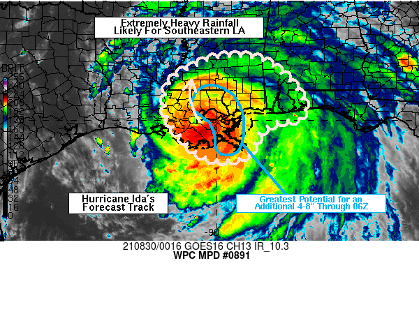
Summary...Significant heavy rainfall and flash flooding associated
with Hurricane Ida will continue to impact southeastern LA into
southern MS over the next 6 hours. An additional 4-8 inches is
expected to the right of Ida's forecast track, some of which will
fall on top of a broad 4-8 inches which has already fallen.

Discussion...GOES East infrared satellite imagery has shown
warming within the central dense overcast (CDO) surrounding
Hurricane Ida's eye over the past 2-3 hours but Ida remains a
major hurricane with well defined banding of heavy rain in the
northern and eastern eyewall. Observed rainfall rates over
southeastern LA have generally been 1-2 in/hr through early
evening, but rates over 2 in/hr have occasionally been observed as
well. At 00Z, Ida was located roughly 25 miles WSW of New Orleans
and tracking toward the northwest near 9 kt according to the 00Z
NHC update. This motion will continue to focus the heaviest
rainfall rates to the immediate north and east of Ida's eye as the
hurricane tracks toward southwestern MS tonight.

VAD wind data from KLIX appears to be located within the core of
strongest 850 mb winds near 80 kt, located about 60 miles of the
center of Ida, supporting extreme moisture transport toward the
north. To the south of Ida, recent radar imagery showed spiral
rain bands south of the MS River Delta, feeding cyclonically
toward the northeast and north into far southeastern LA along with
a separate banded feature into southern MS. These banded
structures are likely to continue over the next several hours,
with the greatest persistence forecast over southeastern LA, from
the marshes of the MS River Delta to north of Lake Pontchartrain
and into portions of adjacent southern MS...where an additional
4-8 inches of rain is expected through 06Z. Farther to the east,
training of outer rain bands within about 100 miles of the MS and
AL Gulf Coast will likely result in rainfall rates varying between
1-3 in/hr and areas of flash flooding. Additional 6-hour rainfall
from these training bands away from the center of Ida are expected
to produce an additional 2-4 inches of rain through 06Z.

Otto

ATTN...WFO...JAN...LCH...LIX...MOB...

ATTN...RFC...LMRFC...SERFC...NWC...

LAT...LON   32138957 32018858 31618786 31158745 30748716
            30158709 29978795 29698853 28938890 28688971
            28889055 29619131 30319168 31279156 31919050
Last Updated: 821 PM EDT Sun Aug 29 2021
|


