| WPC Met Watch |
|
|
Mesoscale Precipitation Discussion: #0953 (2019) |
|
(Issued at 1019 PM EST Wed Nov 06 2019
) |
|
| MPD Selection |
|
|
|
|
|

Mesoscale Precipitation Discussion 0953
NWS Weather Prediction Center College Park MD
1019 PM EST Wed Nov 06 2019

Areas affected...northern TX into central/eastern OK

Concerning...Heavy rainfall...Flash flooding possible

Valid 070315Z - 070915Z

Summary...A broad area across northern TX into central and eastern
OK will see favorable conditions for heavy rain over the next few
hours. Maximum 6 hour rainfall totals of 2-3 inches, locally
higher, are expected which may cause flash flooding.

Discussion...Regional radar imagery at 03Z showed two axes of
moderate to heavy rainfall, one extending from north-central OK
into northwestern AR and a second axis stretching WSW-ENE from
northwestern TX into southeastern OK. 00Z soundings and recent GPS
measurements indicated OK/TX precipitable water values were 1.2 to
1.6 inches (near the climatological max for early November) with
the CIRA Layered PW product showing a moisture connection to the
ITCZ in the eastern Pacific, a significant ingredient for flash
flood events. While MUCAPE has decreased since the 00Z balloon
launches, the SPC mesoanalysis page indicated roughly 500-1000
J/kg remained across much of the region at 03Z. Flow is generally
unidirectional from the southwest to the south of a strong cold
front surging southward from central OK into the TX Panhandle.

A recent increase in convective development to the north of
Oklahoma City will likely continue to linger within a coupled jet
region with enhanced divergence aloft with movement off toward the
east into a region of 14 day precipitation anomalies containing
200-400 percent above average in eastern OK. Therefore, there is a
short term flash flood threat from central to eastern OK before
the cold front from the north passes by.

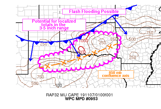
Farther south, the RAP has been consistent in showing an increase
in 850 mb confluent flow extending from northwestern TX...north of
I-20...to southeastern OK after 04Z. This axis of forecast low
level confluence looks to remain nearly stationary until about 09Z
at which point the cold front from the north begins to shift the
confluence axis southward. This region, from northwestern TX into
southeastern OK, is expected to see the greatest potential for
heavy rain and flash flooding with localized 6-hr totals of 3-5
inches.

Otto

ATTN...WFO...FWD...LUB...LZK...MAF...OUN...SHV...SJT...TSA...

ATTN...RFC...ABRFC...LMRFC...WGRFC...

LAT...LON   35979652 35919584 35779449 35299425 34649442
            33839474 33389516 33059602 32799700 32569937
            32450132 33430191 33890022 34169940 35469804
            35829744
Last Updated: 1019 PM EST Wed Nov 06 2019
|


