| WPC Met Watch |
|
|
Mesoscale Precipitation Discussion: #0967 (2018) |
|
(Issued at 226 PM EDT Thu Oct 11 2018
) |
|
| MPD Selection |
|
|
|
|
|

Mesoscale Precipitation Discussion 0967
NWS Weather Prediction Center College Park MD
226 PM EDT Thu Oct 11 2018

Areas affected...Central and Southern Virginia, Northwest North
Carolina

Concerning...Heavy rainfall...Flash flooding likely

Valid 111824Z - 112330Z

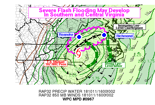
Summary...Flash flooding is likely in NW North Carolina and C/S
Virginia this afternoon due to significant rainfall expected from
Tropical Storm Michael. Severe, life-threatening flash flooding
with deeper inundation and numerous impacted roads is growing
increasingly likely in portions of southwest and south-central
Virginia, where rain rates may exceed 2-3 in/hr at times.

Discussion...Concern is growing for increasingly impactful flash
flooding this afternoon just to the north of the expected track of
Tropical Storm Michael. The left-of-track rainfall maximum is
fairly common with tropical cyclones interacting with an
approaching front, and this has been no different. In addition to
the usual increasingly focused low-level convergence just ahead
and left of the track, the rainfall has likely been enhanced thus
far by the terrain in western North Carolina and Virginia.
Flooding is likely to continue in western North Carolina this
afternoon, even as rain begins to taper off behind the tropical
cyclone center.

Regional radars have shown more substantial rain bands becoming
concentrated just northwest and north of Michael's center, on the
nose of strong low-level inflow. The KRAX radar VWP has been
sampling SSE winds at 850mb on the order of 50-60 knots. NWP
models show increasing convergence into the afternoon. The KRNK
VWP showed 850mb winds backing from the northeast to the northwest
and increasing to around 40 knots over the past couple hours
(16-18Z) and this supports the model forecasts of increasing
convergence. Therefore, it's unsurprising that the available
hi-res models have a strong signal for significant rainfall totals
in southern and central Virginia over the next several hours
(18-00Z). The 12Z HREF blended mean has 6-hr amounts as high as
6-7 inches, which would have less than a 1 percent annual
exceedance probability based on the local climatology. Although
these type of amounts may be overdone on a large scale, narrow
swaths could achieve these amounts given that nearly every hi-res
model is in agreement. The strength of the low-level convergence,
and possibility of orographic enhancement for another hour or two
(before Michael begins pulling away with wind direction shifting
to a less favorable orientation) also strongly suggest a
significant band of heavy rainfall. And furthermore, the
precipitable water values near all time records are suggestive of
highly efficient, tropical rain rates.

Therefore, severe, life-threatening flash flooding appears
increasingly likely across parts of southern and central Virginia.
Rain rates may exceed 2-3 in/hr at times, and some local mesonet
and public weather stations in the Roanoke area have already
observed this at times. Numerous roads may become flooded or
impassable over the next several hours, and as 00Z approaches, the
more significant rain rates may begin to approach points further
east like the Richmond Metro Area.

Lamers

ATTN...WFO...AKQ...GSP...LWX...RAH...RNK...

ATTN...RFC...MARFC...OHRFC...SERFC...

LAT...LON   38127845 37997744 37227750 36747830 36217946
            35898080 36598096 37568008
Last Updated: 226 PM EDT Thu Oct 11 2018
|


