| WPC Met Watch |
|
|
Mesoscale Precipitation Discussion: #0976 (2021) |
|
(Issued at 246 PM EDT Thu Sep 16 2021
) |
|
| MPD Selection |
|
|
|
|
|

Mesoscale Precipitation Discussion 0976
NWS Weather Prediction Center College Park MD
246 PM EDT Thu Sep 16 2021

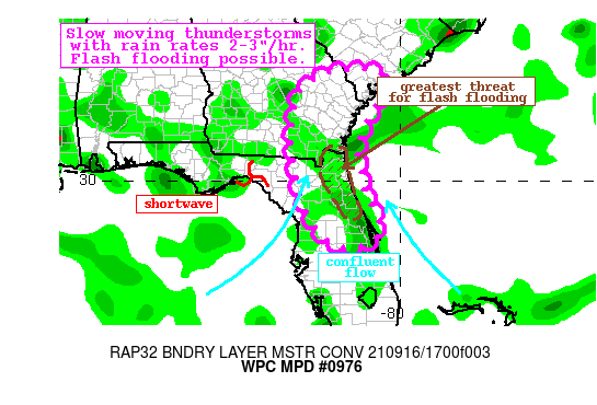
Areas affected...Northeast Florida, Southeast Georgia, Southeast
South Carolina

Concerning...Heavy rainfall...Flash flooding possible

Valid 161845Z - 170030Z

Summary...Thunderstorms developing along a low-level convergence
axis will expand in coverage and drift across the area into this
evening. Rainfall rates may reach 3"/hr at times. Flash flooding
is possible.

Discussion...The regional radar mosaic this aftn indicates
scattered thunderstorms developing across parts of the northern FL
Peninsula and into southeast Georgia. These storms are developing
in response to a shortwave lifting eastward across FL/GA, and
convergent moist flow near the Atlantic Coast. PWs according to
the recent Blended TPW product are above 2.25", and the 12Z U/A
soundings out of KJAX and KCHS indicated nearly moist adiabatic
lapse rates through 300mb with freezing levels over 15,000 ft. RAP
analyzed MLCape of 1000-1500 J/kg is contributing to this
convective development as well, and together these suggest
efficient warm rain processes which are materializing as
radar-estimated rain rates of 2"/hr on the KJAX WSR-88D.

Deep SW flow out of the Gulf of Mexico will persist into this
evening driving even higher PWs northward, while modest S/SE flow
along the Atlantic Coast of FL drives local convergence across the
eastern Peninsula. Mean 0-6km winds are progged to be S/SW at
around 10 kts, and with low-level convergence remaining nearly in
place through the evening, repeated rounds of thunderstorms are
possible. Additionally, the shortwave near the Big Bend of FL
should continue to advect to the east, driving additional ascent
to expand convective coverage, and the high-res CAMs all indicate
scattered to widespread coverage of 1-3", with local maxima to 5"
possible.

Although FFG across the area is high, this does not account for
rainfall that has fallen already this morning which has exceeded
3" according to MRMS leading to saturated top soils. Additionally,
FFG along the urban corridor of I-95, including the Jacksonville
metro area is likely much lower as well. HREF probabilities for
1-hr rain rates show a greater than 60% chance for 2"/hr, and
focuses the highest probabilities for 3"/3hrs along this I-95
corridor of NE FL. This is also where the exceedance probabilities
for 1-hr and 3-hr FFG are highest. While the coverage of heavy
rain producing thunderstorms is likely to remain scattered and
disorganized, storm mergers and outflow interactions could
increase the flash flood threat. The highest risk for flash
flooding is likely to be near the urban corridor of I-95 including
Jacksonville, but isolated flash flooding is possible anywhere
within the MPD area until nocturnal stability develops late this
evening.


Weiss

ATTN...WFO...CHS...FFC...JAX...MLB...TBW...

ATTN...RFC...SERFC...NWC...

LAT...LON   32918076 32768046 32398046 32128050 31708083
            31118106 30838115 30138103 29688094 29198068
            28728051 28378085 28248142 28488194 29218247
            30078268 30528277 30988284 32068273 32538243
            32788193 32868144
Last Updated: 246 PM EDT Thu Sep 16 2021
|


