| WPC Met Watch |
|
|
Mesoscale Precipitation Discussion: #1014 (2018) |
|
(Issued at 1250 AM EST Fri Nov 09 2018
) |
|
| MPD Selection |
|
|
|
|
|

Mesoscale Precipitation Discussion 1014
NWS Weather Prediction Center College Park MD
1250 AM EST Fri Nov 09 2018

Areas affected...South-Central Texas

Concerning...Heavy rainfall...Flash flooding possible

Valid 090550Z - 091030Z

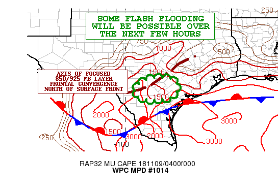
Summary...Showers and thunderstorms will continue over the next
few hours with locally very heavy rainfall rates. Some flash
flooding will be possible.

Discussion...The latest radar imagery continues to show a more
expansive axis of showers and thunderstorms evolving over
south-central TX as a broad warm advection pattern allows a pool
of elevated instability to lift well north of a surface front
focused over far south TX. Meanwhile, moisture transport has been
increasing with PWATS now as high as 1.6 to 1.8 inches. The
activity has been generally focusing along an axis of focused
850/925 mb layer frontal convergence, and is also being aided by
proximity of 250 mb right-entrance region jet dynamics.

Over the next several hours, the axis of elevated convection
should begin to gradually shift farther east, but there will be
some areas of regenerating and thus repeating cell activity since
the pool of instability should remain in place and with at least a
modest degree of deep layer ascent through the remainder of the
night.

Expect rainfall amounts of as much as 2 inches/hr locally, and
storm totals going through dawn of as much as 3 to 4+ inches. The
heaviest rainfall amounts should be confined to the southern
suburbs of the San Antonio metropolitan area, and some flash
flooding will be possible.

Orrison

ATTN...WFO...CRP...EWX...

ATTN...RFC...WGRFC...

LAT...LON   29659818 29599743 29359713 28939712 28559748
            28439809 28429863 28559920 28799950 29259932
            29529883
Last Updated: 1250 AM EST Fri Nov 09 2018
|


