| WPC Met Watch |
|
|
Mesoscale Precipitation Discussion: #1017 (2018) |
|
(Issued at 359 AM EST Thu Nov 15 2018
) |
|
| MPD Selection |
|
|
|
|
|

Mesoscale Precipitation Discussion 1017
NWS Weather Prediction Center College Park MD
359 AM EST Thu Nov 15 2018

Areas affected...East-Central GA...Upstate SC...Central NC

Concerning...Heavy rainfall...Flash flooding possible

Valid 150858Z - 151358Z

Summary...Widespread moderate rainfall will bring additional
totals of 1 to locally 3" and combined with the extremely wet
antecedent conditions, could result in localized flooding.

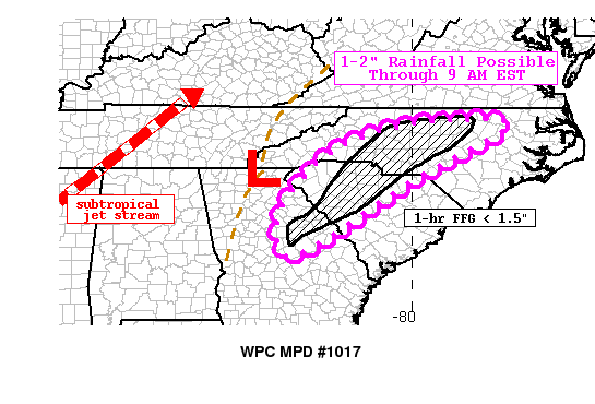
Discussion...A broad area of upper level divergence exists across
portions of the southeast US, associated with a closed low over
the mid-MS River Valley. A plume of subtropical moisture has
pulled anomalously high PWATs up into portions of Georgia, South
and North Carolina. Strong frontogenetic forcing overrunning the
area has led to a few focused areas of heavier rainfall across
portions of east-central GA into upstate SC, with radar estimates
indicating hourly rates between 1-1.5".

The RAP 850-700 mb frontogenesis fields suggest the potential for
a narrow, focused areas of heavier rainfall across portions of
upstate SC then spreading into portions of central NC through the
mid morning hours. There is relatively good agreement in the
hi-res models showing potential for an additional 1-2" with
locally 3" amounts possible through 14z / 9 am EST.

Antecedent conditions in these areas are extremely wet with 7 day
percent of normal running between 400-600 percent. 1- and 3-hr FFG
values are low, particularly across central NC. With rivers,
streams, and creeks already running high, additional runoff could
lead to flooding issues, especially in and around urban areas.

As a result of the expected rainfall and wet conditions, some
localized flooding issues are possible through the morning hours.

Taylor

ATTN...WFO...CAE...FFC...GSP...ILM...RAH...

ATTN...RFC...SERFC...

LAT...LON   36187746 35047931 34518024 32718307 33568351
            34708289 35608174 36167991
Last Updated: 359 AM EST Thu Nov 15 2018
|


