| WPC Met Watch |
|
|
Mesoscale Precipitation Discussion: #1040 (2022) |
|
(Issued at 241 AM EDT Tue Sep 27 2022
) |
|
| MPD Selection |
|
|
|
|
|

Mesoscale Precipitation Discussion 1040
NWS Weather Prediction Center College Park MD
241 AM EDT Tue Sep 27 2022

Areas affected...South Florida and the Florida Keys

Concerning...Heavy rainfall...Flash flooding possible

Valid 270640Z - 271240Z

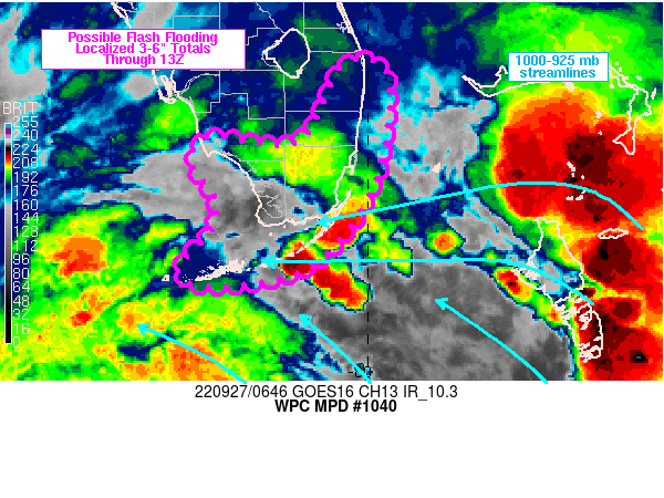
Summary...Locally heavy rain is likely to affect locations from
the Florida Keys into the southern and southeastern coast of
Florida through the morning. Rainfall rates as high as 3 in/hr
will be possible along with 6-hr totals in the 3-6 inch range,
which may result in localized areas of flash flooding.

Discussion...Regional radar imagery over southern FL has shown an
increase over the past 1-2 hours in the coverage of showers and
thunderstorms extending from the Lower Florida Keys to the Straits
of Florida west of Andros Island. These storms were tied to
distant outer rainbands to the north of Hurricane Ian (Ian's
center located just south of western Cuba at 06Z) within a broad
region of divergence aloft / northern outflow channel noted on
infrared satellite imagery. Transient axes of low level
convergence have supported scattered showers/thunderstorms over
the past few hours but larger scale confluence of streamlines in
the 1000-925 mb layer was aligned with the orientation in the
recent uptick in convective coverage in the vicinity of the
southern Florida coast.

The moist environment (2.2 to 2.5 inch precipitable water values)
and similarly oriented 850 mb + 850-300 mb layer winds from the
SSE have already supported slow movement and training of mini
supercells along the Florida Keys over the past few hours with
peak MRMS rates near 3 in/hr. The current axis of
showers/thunderstorms along the Keys to just off of the
southeastern coastline is expected to slowly translate northward
over the next 3-6 hours along with increasing instability along
coastal sections of southeastern Florida. Periods of training and
backbuilding of individual cells are expected to continue with
impacts spreading from the Keys into southern and southeastern
Florida through the morning. Rainfall rates near 3 in/hr will be
possible along with a few 6-hr totals in the 3-6 inch range. While
the coverage of the higher end rainfall totals should remain
fairly localized, flash flooding will be possible if overlap
occurs with any urban or otherwise poorly draining surfaces.

Otto

ATTN...WFO...KEY...MFL...

ATTN...RFC...SERFC...NWC...

LAT...LON   26848021 26837988 26487977 25497996 24708061
            24488166 24668199 25078163 25428161 25708181
            25898186 26068163 25978116 26028067 26558040
Last Updated: 241 AM EDT Tue Sep 27 2022
|


