| WPC Met Watch |
|
|
Mesoscale Precipitation Discussion: #1046 (2022) |
|
(Issued at 941 AM EDT Wed Sep 28 2022
) |
|
| MPD Selection |
|
|
|
|
|

Mesoscale Precipitation Discussion 1046
NWS Weather Prediction Center College Park MD
941 AM EDT Wed Sep 28 2022

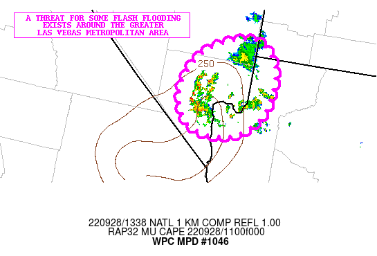
Areas affected...Far Southern NV...Far Northwest AZ

Concerning...Heavy rainfall...Flash flooding possible

Valid 281340Z - 281740Z

SUMMARY...Scattered showers and thunderstorms may produce some
flash flooding concerns around the greater Las Vegas metropolitan
area over the next few hours.

DISCUSSION...The latest radar imagery shows some showers and
thunderstorms developing over Clark County in far southern NV with
cells focusing in and around the greater Las Vegas metropolitan
area. A few cells are also seen over parts of Mohave County in far
northwest AZ. The activity is forming in response to an
approaching shortwave trough which is interacting with a
north/south axis of mid-level moisture nosing up from southeast CA
and into southern NV.

In fact, the latest RAP analysis shows PWs of 1.0 to 1.1 inches
early this morning and this is as much as 2 to 3 standard
deviations above normal for this time of the year. Coinciding with
this rather narrow moisture plume is an axis of modest elevated
instability with MUCAPE values of 500+ j/kg. The forcing with the
approaching shortwave energy may allow for some expansion of
convective cells over the next few hours, although generally the
coverage should remain rather scattered.

Rainfall rates are going to be capable of reaching 1 inch/hour,
with much of this in as little as 30 minutes with some of the
stronger convective cells. The HREF guidance and recent HRRR runs
are rather ill-defined with the convective potential this morning,
but do support at least some convective development in time going
through the latter part of the morning time frame.

Radar trends would suggest potentially as much as 1 to 2 inches of
rain for a few isolated locations over the next few hours. This
coupled with especially the heavier sub-hourly rainfall rate
potential suggests at least some concern for runoff problems and
flash flooding. There will be some urban sensitivities to note
given the rainfall threat locally around the Las Vegas
metropolitan area.

Orrison

ATTN...WFO...SLC...VEF...

ATTN...RFC...CBRFC...CNRFC...NWC...

LAT...LON   37251411 36881359 36211360 35821388 35601430
            35591491 35811531 36341544 36971503
Last Updated: 941 AM EDT Wed Sep 28 2022
|


