| WPC Met Watch |
|
|
Mesoscale Precipitation Discussion: #1053 (2022) |
|
(Issued at 505 AM EDT Fri Sep 30 2022
) |
|
| MPD Selection |
|
|
|
|
|

Mesoscale Precipitation Discussion 1053
NWS Weather Prediction Center College Park MD
505 AM EDT Fri Sep 30 2022

Areas affected...Coastal North Carolina...

Concerning...Heavy rainfall...Flash flooding possible

Valid 300905Z - 301430Z

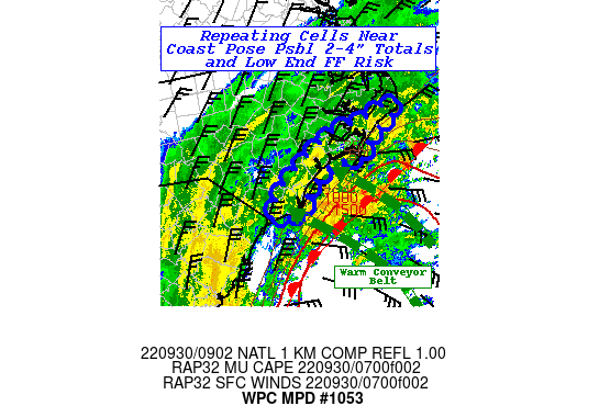
SUMMARY...Repeating cells along the front near the coast with
rates of 1.5-2"/hr and 3-4" totals may reach short-term FFG and
may be a flooding issue given strong onshore flow combination with
coastal flooding.

DISCUSSION...GOES-E IR/WV suite depicts a hybrid depiction in the
cloud pattern, with increasingly stark extratropical features
including a well defined warm conveyor belt increasing distance
toward the east from the center of Ian.  Currently this plume
extends from the N Bahamas and arcs back north and northeast
generally oriented north and east of the NC/SC border.  An 08z
surface analysis utilizing buoy/ship data suggest warm front
remains a bit off shore about 60 nmi from Bald Head to the
southeast and about 75nmi from Cape Fear southeast.  Orthogonal
flow at the boundary with strong 35-45kt southeasterly flow is
isentropically ascending over this boundary.  MUCAPE gradient
exists for the sharpness of the boundary with 2000 J/kg in the
warm sector rapidly decreasing to <500 J/kg at the coast per RAP
analysis.  Still, mid to upper 70s Tds and moist sounding through
the warm conveyor to 7-5H, support 2.25-2.4" Total PWats
indicating very strong moisture flux convergence that even
stratiform/slantwise ascent should be very efficient.  RADAR
mosaic suggests some convective elements trying to form at the
frontal zone, but quickly weaken/shear as they approach the coast.
 As such, rates of 2-2.5"/hr will not likely reach shore until the
front passes which appears to be timing in the mid-morning/late
morning time frame of 13-14z.  Still, weaker blow-off could still
result in hourly rates of 1-1.5", but will likely be streaky from
south to north along the NC coast given parallel convergence bands
in the warm conveyor belt.  So there is lower confidence in
timing, but given proximity to Ian's center, the western side of
the bands near ILM have a higher probability to reach shore an
hour or so earlier perhaps by 12z.

Given upstream redevelopment along these bands, totals could
increase rapidly to 3-4" by 15z.  Combination with strong onshore
flow...runoff will not likely flow out to sea and could pile up
more than normal across the sandy soils near the coast.  As such,
there is a low possibility that flash flooding/rapid inundation
flooding may occur even with high FFG values (4-5" in 3-6hrs).

Gallina

ATTN...WFO...ILM...MHX...

ATTN...RFC...SERFC...NWC...

LAT...LON   35407561 35217549 35127574 34887620 34557651
            34607704 34267765 33827792 33867822 33907855
            34397819 35067708 35187629
Last Updated: 505 AM EDT Fri Sep 30 2022
|


