| WPC Met Watch |
|
|
Mesoscale Precipitation Discussion: #1058 (2022) |
|
(Issued at 356 PM EDT Fri Sep 30 2022
) |
|
| MPD Selection |
|
|
|
|
|

Mesoscale Precipitation Discussion 1058
NWS Weather Prediction Center College Park MD
356 PM EDT Fri Sep 30 2022

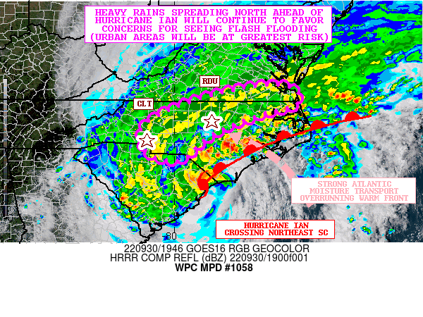
Areas affected...Central to Northeast NC...Far Southeast VA

Concerning...Heavy rainfall...Flash flooding possible

Valid 301955Z - 010155Z

SUMMARY...Heavy rains associated with Hurricane Ian continue to
advance north across the interior of the southern Mid-Atlantic.
Areas of flash flooding will be possible, but with the greatest
potential over the more urbanized areas, including the Charlotte
and Raleigh-Durham-Chapel Hill (Triangle) metropolitan areas.

DISCUSSION...Hurricane Ian made landfall at 2:05 pm EDT near
Georgetown, SC as a 85 mph CAT 1 storm, and since then has been
moving steadily to the north and inland across northeast SC. This
motion will continue to allow for heavy rains to continue spread
north and well inland across the southern Mid-Atlantic region
heading through the remainder of the afternoon and into the
evening hours.

GOES-16 satellite imagery depicts Ian increasingly transitioning
toward an extratropical state as it comes under strong influence
of an upper trough over the Southeast and a well-defined front in
close proximity to the storm. A warm front is seen now advancing
inland across eastern NC and this will continue to interact with
very moist and unstable deep layer southeast flow coming in off
the Atlantic Ocean around the northeast flank of Ian's
circulation.

As this front gains latitude and advances farther inland, the axis
of stronger isentropic ascent and enhanced frontogenetical forcing
will also advance inland. This coupled with the enhanced moisture
transport and high PW environment (locally 2+ inch PWs), and a
nose of modest elevated instability (MUCAPE values ~500 j/kg), the
rainfall rates should increase and may locally reach 1 to 2
inches/hour with a few stronger convective cells.

Additional rainfall of as much as 2 to 4 inches is expected for
the MPD area involving central to northeast NC and into southeast
VA going through mid-evening. Locally heavier rainfall amounts
will be possible and especially for areas of northeast NC and far
southeast VA where somewhat greater instability parameters and
low-level forcing will be in place heading into the evening hours.
These additional rainfall amounts are supported by the recent HRRR
guidance and radar trends.

Areas of flash flooding will be possible, with the greatest
concerns involving the more urbanized areas. This will include
Charlotte and the NC Triangle (Raleigh-Durham-Chapel Hill)
vicinity. Portions of southeast VA including the Hampton Roads
area will also need to be monitored for somewhat elevated risk of
runoff problems heading into this evening.

Orrison

ATTN...WFO...AKQ...CAE...GSP...ILM...MHX...RAH...RNK...

ATTN...RFC...MARFC...SERFC...NWC...

LAT...LON   37097691 36987605 36467595 36087727 35447880
            34617982 34888090 35628110 36158038 36637913
            36937788
Last Updated: 356 PM EDT Fri Sep 30 2022
|


