| WPC Met Watch |
|
|
Mesoscale Precipitation Discussion: #1060 (2022) |
|
(Issued at 512 PM EDT Fri Sep 30 2022
) |
|
| MPD Selection |
|
|
|
|
|

Mesoscale Precipitation Discussion 1060
NWS Weather Prediction Center College Park MD
512 PM EDT Fri Sep 30 2022

Areas affected...Eastern North Carolina

Concerning...Heavy rainfall...Flash flooding possible

Valid 302110Z - 010030Z

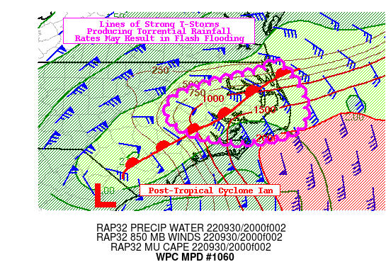
SUMMARY...Strong thunderstorms producing torrential rainfall rates
in areas where soils are growing increasingly sensitive could
result in additional areas of flash flooding for a few more hours.

DISCUSSION... The warm front lifting north and west across North
Carolina is allowing for the warm sector to continue its
progression northward through the North Carolina Tidewater. RAP
forecast guidance shows MUCAPE of 1,000-2,000 J/kg while a
corridor of >2" PWs remains in place for a few more hours. The 19Z
HRRR area averaged sounding that include the Outer Banks and
Albemarle Sound for 23Z also showed low-mid level RH values of
~90% and warm cloud layers as deep as 13,000-14,000' AGL. With the
front acting as a trigger and a steady 850mb moisture transport
overrunning the surface warm front to the northeast of Ian,
thunderstorms will continue to form where atmospheric moisture
remains abundant. MRMS instantaneous rainfall rates are still
peaking as high as 3-4"/hr in some cases, and given FLASH CREST
soil moisture values are as high as 75% along some of the coastal
communities bordering the Albemarle and Pamlico Sounds, these
storms could still produce areas of flash flooding for a few more
hours in flood prone areas.

Over the next several hours, a dry slow in the 700-300mb layer
will soon help to conclude the excessive rainfall threat, first
down in the Cape Fear's Lower Basin (currently concluding), then
on north through the Pamlico Sound (~22-23Z) and finally the
Albemarle Sound and Outer Banks (~23-00Z). Some areas as far north
as Elizabeth City may still contend with strong storms through
00Z, which corresponds well with the newest 18Z HREF showing 3-hr
QPF > 3-hr FFGs probabilities up to 70% between 21-00Z. It will be
urbanized communities, poor drainage spots, and locations along
creeks and streams that are most at-risk for flash flooding for a
few more hours.

Mullinax

ATTN...WFO...AKQ...MHX...RAH...

ATTN...RFC...SERFC...NWC...

LAT...LON   36557581 36317550 35897522 35427519 35307521
            35117558 34987627 35037701 35287774 35577794
            35867775 36167690 36387604
Last Updated: 512 PM EDT Fri Sep 30 2022
|


