| WPC Met Watch |
|
|
Mesoscale Precipitation Discussion: #1075 (2022) |
|
(Issued at 159 AM EDT Wed Oct 05 2022
) |
|
| MPD Selection |
|
|
|
|
|

Mesoscale Precipitation Discussion 1075
NWS Weather Prediction Center College Park MD
159 AM EDT Wed Oct 05 2022

Areas affected...Southern CT...Southern RI...Middle and Eastern
Long Island...

Concerning...Heavy rainfall...Flash flooding possible

Valid 050600Z - 051100Z

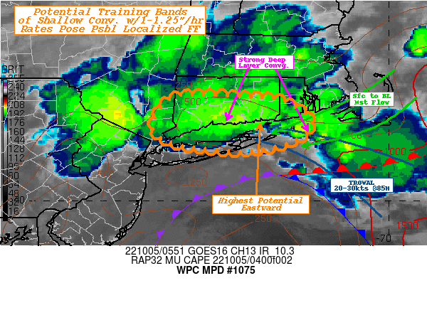
SUMMARY...Favorable few hours of training shallow convection
bands.  Localized 1.5-3" totals resulting in localized possible
flooding.

DISCUSSION...GOES-E WV suite depicts deep closed low in the NW
Atlantic centered just off the the Delmarva peninsula.  While the
main center is further southwest, there is a shortwave elongating
the wave along the eastern side lifting north.  This is providing
solid DPVA and some modest diffluence aloft across southeastern
New England at 3H.  In response, tightening FGEN exists from an
apparent triple-point near 40.4N 71.8W and strengthening warm
conveyor belt has been pumping warmer unstable air along and
northwest across E Long Island toward southern New England. Rap
analysis suggests increased confluence through this western branch
of the TROWAL from 925-85H coincident with 1.5" Total PWat values
and increasing winds from 25kts to 30-35kts.  Instability values
range from 500-1000 J/kg from the tip of Long Island back
southeastward, and rapidly decrease across CT into S NY.  Still,
strong convergence and tightening flow under the influence of the
approaching shortwave energy has resulted in some shallow
convective development in/along the TROWAL with tops cooling below
-50C.  Steering flow should corral these bands for a few hours
tracking across E LI toward north-central LI and perhaps ashore
across CT into S RI.  Rates of 1"-1.25"/hr are possible and may
result in localized totals of 2-3" in 3-4hrs.

There is low to slightly below average confidence in placement and
motion of the band would reduce overall totals locally. While more
than half of reliable Hi-Res CAMs, including recent HRRR solutions
suggest limited training...current trends in RADAR/IR along with
environmental parameters appear provide sufficient evidence that
training may result over land, though is backed up by the FV3CAM
and is hinted in the GFS and other global guidance with lower
resolution. Regardless, strong onshore flow is likely to further
limit river/stream outflow allowing for backed-up streams, so any
areas receiving 2"+ in 3-4/hr would be more prone to localized
flooding concerns.

Gallina

ATTN...WFO...ALY...BOX...OKX...

ATTN...RFC...NERFC...NWC...

LAT...LON   41727303 41667192 41537157 41287126 40977158
            40817244 40947351 41217387 41657360
Last Updated: 159 AM EDT Wed Oct 05 2022
|


