| WPC Met Watch |
|
|
Mesoscale Precipitation Discussion: #1085 (2021) |
|
(Issued at 1016 PM EDT Wed Oct 13 2021
) |
|
| MPD Selection |
|
|
|
|
|

Mesoscale Precipitation Discussion 1085
NWS Weather Prediction Center College Park MD
1016 PM EDT Wed Oct 13 2021

Areas affected...Central to Southwest MO...Northwest AR...Eastern
OK...

Concerning...Heavy rainfall...Flash flooding likely

Valid 140215Z - 140800Z

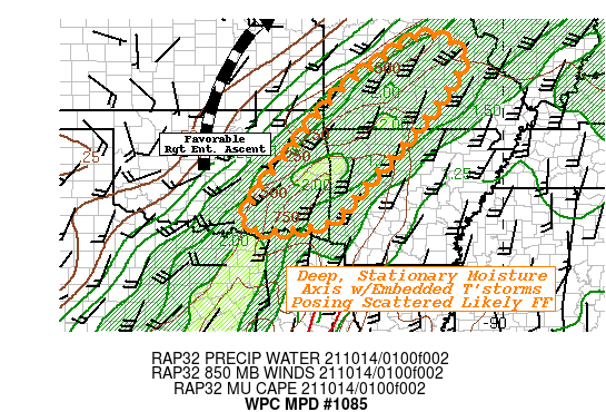
SUMMARY...Multiple bouts of efficient rainfall producing
thunderstorms across a stationary deep moisture axis likely to
produce pockets of flash flooding overnight.

DISCUSSION...The 00z SGF sounding is a great example of the deeply
saturated environment traced back to the sub-tropical Pacific and
moisture associated with T.C. Pamala.  Moist adiabatic though
along/just east of the deeper axis and mid-level moisture/rain
shield, there remains a narrow ribbon of weak to modest
instability of 500-1000 J/kg.  Still, with some mid to upper level
forcing and modest upglide ascent along weak cold pools/outflows
in proximity to diffuse surface boundary from NE TX across E OK
provides localized moisture convergence for stronger vertical
development.  While it is a bit more slanted given the shallow
cold pools, the mean flow supports training through the deeper
SW-NE atmospheric river.

Upstream, GOES-E WV suite denotes a nice anti-cyclonically curved
cirrus pattern across W OK into KS suggestive of strong/tight
gradient to the right entrance of the upper-level jet.  This
provides ample upper-level divergence to enhance the convection to
support occasional rates up to 2"/hr.  Given the training
potential, pockets of 2-4" totals remain possible.  Given recent
rainfall throughout the day, FFG values have fallen in response
and the general <2"/hr values are likely to be eclipsed but in a
scattered pattern from the Red River through the Ozarks.   The
aforementioned shortwave ridging aloft will flatten but the wave
will continue north-northeast along the axis and not waver too
much for eastward propagation.  As such, heavy rainfall will
expand northward into the complex terrain of MO with 2-3" totals
possible through 08z and similar though likely a bit further
scattered in nature for flash flooding conditions.

Gallina

ATTN...WFO...LSX...LZK...OUN...SGF...SHV...TSA...

ATTN...RFC...ABRFC...LMRFC...MBRFC...NCRFC...NWC...

LAT...LON   38889190 38389105 37559146 36419237 35259347
            34149452 33989635 34419656 35859550 37259434
            38419290
Last Updated: 1016 PM EDT Wed Oct 13 2021
|


