| WPC Met Watch |
|
|
Mesoscale Precipitation Discussion: #1130 (2022) |
|
(Issued at 1235 PM EST Thu Nov 24 2022
) |
|
| MPD Selection |
|
|
|
|
|

Mesoscale Precipitation Discussion 1130
NWS Weather Prediction Center College Park MD
1235 PM EST Thu Nov 24 2022

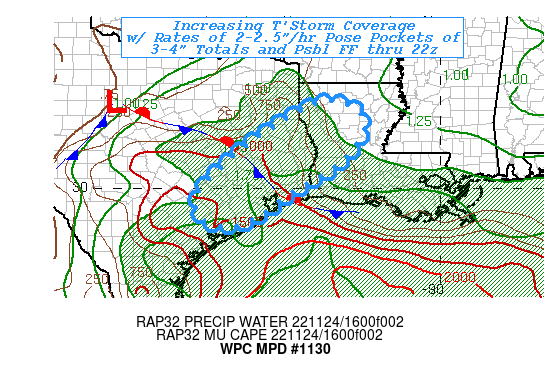
Areas affected...Southeast to Eastern TX...Western LA...

Concerning...Heavy rainfall...Flash flooding possible

Valid 241735Z - 242215Z

SUMMARY...Increasing convective coverage is expected over the next
few hours.  Strong cells with rates up to 2"/hr and training pose
areas of 3-4" totals and possible flash flooding into the evening
hours.

DISCUSSION...17z surface analysis shows a weak surface wave east
of DYS with a stationary front draping eastward to near ACT before
angling southeast toward the Houston Metro.  A weak outflow
boundary from elevated convection across the Hill county continues
to consolidate frontogenesis/moisture convergence at the
intersection of increasing deep moisture/higher Theta-E air mass
off the Gulf.  Tds rapidly increase from upper 50s to upper 60s
across this SW to NE boundary from ERV to T35 toward the warm
front, with low 70s values starting to come ashore.  This along
with steeping mid-level lapse rates and some weak filtered
insolation across the central coastal plain of TX has resulted in
increasing instability with SBCAPES up to 2000 J/kg though the
warm sector is broadly increasing to 1500 J/kg of MLCAPE. While
the warm sector is south of the upper level jet and in the right
exit region, weak diffluence will be increasing as the upper level
close low digs south and intensifies this afternoon, increasing
upper-level divergence support.

Currently, a few thunderstorm clusters exist at the best
convergence near the warm front/Galveston Bay and upstream in
Jackson and Dewitt county. Total PWats are increasing to 1.75" and
with convergence/moisture loading updrafts will continue to expand
and become more efficient.  Rates of 2"/hr are becoming
increasingly likely with some short-term/occasional rates up to
2.5"/hr are probable as instability and upper-level support
increase with time toward 21-22z.   Deep layer steering should
support training profile for the axis from SW to NE, potentially
across Metro Houston later this afternoon.  Hi-Res CAMS continue
to struggle with the latitude of the convective axis though trends
suggest recent HRRR cycles and ARW2 seem to be on best placement
(perhaps still a tad north) so that remains the greatest
uncertainty/lowest confidence at this time.  Training cells with
localized totals of 3-4" are becoming probable across the area of
concern and as such flash flooding is considered possible, though
becoming more likely after 22z (and a subsequent MPD to discuss
evolution into the overnight period will be likely later today).

Further north into W LA...Elevated cells at the apex of the warm
sector/MUCAPE nose are likely to continue training and while
intensity of rates will be lower 1.5" with occasional 1.75"+/hr
rates, isolated 2-3" totals could pose some localized flooding
concerns as well.

Gallina

ATTN...WFO...EWX...HGX...LCH...SHV...

ATTN...RFC...LMRFC...WGRFC...NWC...

LAT...LON   32489337 32039220 31219243 30479322 30059400
            29559472 28939583 29109680 29919689 31109568
            31549508
Last Updated: 1235 PM EST Thu Nov 24 2022
|


