| WPC Met Watch |
|
|
Mesoscale Precipitation Discussion: #0187 |
|
(Issued at 701 PM EDT Mon May 18 2026
) |
|
| MPD Selection |
|
|
|
|
|
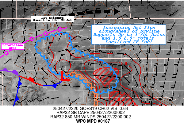
Mesoscale Precipitation Discussion 0187
NWS Weather Prediction Center College Park MD
701 PM EDT Mon May 18 2026

Areas affected...Southwest IA...Southeast NEB...Northwest
MO...Central & Northeast KS...

Concerning...Heavy rainfall...Flash flooding likely

Valid 182300Z - 190500Z

SUMMARY...Strong moisture flux convergence will help to spur
upscale growth from individual supercells to larger clusters with
increasing rainfall potential and coverage.  Rates of 2"/hr+ and
localized totals of 2-4" (isolated 5"), especially across areas
recently saturated are likely to result in increasing incidents of
flash flooding.

DISCUSSION...22z surface analysis and RADAR mosaic have changed
very little over the last few hours though the dryline has surged
out of the OK/TX panhandles and helped concentrate southerly moist
flux to expand convective initiation well into south-central KS.
Main clusters of supercells have are at bit more progressive out
of southeast NEB with some eastward turning and increasing
coverage and has started to move out of MPD 185 area of concern
into SW IA and far NW MO.   Additionally, the remainder of the
cold front from the northern inflection E of Lincoln, NEB and
secondary low near Salina, KS has filled in with broadening
up/downdrafts; as such total PWats have increased along the cold
front as the total column moistens with this increasing coverage.
Tds in the 70s and sub-boundary layer LPW values near 1" along
with 20-30kts of southerly flow continue to provide strong
moisture flux to encourage increasing rainfall efficiency over the
next few hours.

GOES-E WV shows the upper level jet streak is currently rounding
the base of the negative tilt up-level trof over the Northern
Plains and as a result, upper level divergence pattern will
further increase over the next few hours within strengthening DPVA
and right entrance ascent patterns across the frontal zone.  This
should support further upscale growth of the cells toward clusters
as we near sunset.   Cold pool generation, right-turning
supercells, should support further storm-scale interaction for
more eastward propagation allowing some increased short-term
training/repeating (as noted with clusters in NW MO already).  As
such localized streaks of 2-4" totals will become more likely.

Across the MPD area a broadening/divergent of the 500-1000
thickness fields suggests east to southeast forward propagation
with time as well; increasing orthogonal flanking line
intersection to expand back-building potential.  This
slowing/turning could be the greatest further south along the
upstream edge near the nose of the dryline/cold front where
steering flow is just a tad weaker overall aloft and support
longer residency times.   Of course, south-central KS will require
this longer residency given the area has missed out on the
complexes/heavy rainfall over the weekend.

While severe/tornadic hazards remain the primary concern
currently, this will transition toward flash flooding and given
the majority of the area (north of 38.5N latitude) has FFG values
at or below the hourly expected rates (1-1.75"/hr) and generally
less than 2.5"/3hrs.  As such, incidents of flash flooding will
become more likely and with greater overall coverage.  Hi-Res CAMs
including the WoFS/HRRR continue to suggest very intense
sub-hourly totals (1.5"/15 minutes per HRRR) and isolated totals
of 5".

Gallina

ATTN...WFO...DMX...EAX...ICT...OAX...TOP...

ATTN...RFC...KRF...MSR...TUA...NWC...

LAT...LON   41899371 41709307 41259253 40579249 40039284
            39029379 38049551 37489790 37969841 38759779
            40729682 41509594 41829502
Download in GIS format: Shapefile
| KML
Last Updated: 701 PM EDT Mon May 18 2026
|
 weather.gov