| WPC Met Watch |
|
|
Mesoscale Precipitation Discussion: #0625 (2018) |
|
(Issued at 1038 AM EDT Fri Aug 10 2018
) |
|
| MPD Selection |
|
|
|
|
|

Mesoscale Precipitation Discussion 0625
NWS Weather Prediction Center College Park MD
1038 AM EDT Fri Aug 10 2018

Areas affected...Central and North Texas

Concerning...Heavy rainfall...Flash flooding possible

Valid 101437Z - 101907Z

Summary...Areas of rain with embedded clusters of thunderstorm may
persist into the early afternoon across parts of Central and North
Texas. Any thunderstorm clusters should move slowly, and could
therefore produce localized heavy rainfall and possibly some flash
flooding. Rain rates to around 2 in/hr will be possible.

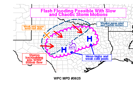
Discussion...A complex mesoscale pattern is in place across Texas
this morning. Persistent convection late overnight has led to at
least one prominent MCV (near KMNZ at 14Z), and several weak cold
pools and mesoscale high pressures (near the Llano Uplift and the
southeast side of DFW metro area). GOES-16 water vapor imagery and
derived motion winds also implied a weak mid-upper level
circulation and vorticity maximum in West Texas. Convection was
back-building to the west and northwest, into moist 850-700mb
inflow as sampled by a variety of radar VWPs from KFWS, to KDYX,
to KSJT. This back-building was producing new convection in a
region of reduced deep layer mean wind speeds and Corfidi vectors.
Therefore, slow storm motions appear likely, in addition to some
chaotic storm motions given the complexity to the flow patterns at
multiple layers of the troposphere due to earlier convection. This
should provide a favorable environment for at least brief stalling
of convective clusters and storm mergers, which may enhance
locally heavy rainfall.

Hi-res models do not appear to have a great handle on the
situation. Many try to make the convective clusters too outflow
dominant, and appear to be too quick to dissipate convection.
While gradual diminishing of intensity and coverage of convection
is possible (given we are very near the typical diurnal convective
minimum), radar and satellite trends suggest some areas of
convection should be sustained for at least a couple more hours.
GOES-16 IR satellite shows two areas of cooling cloud tops, one
closer to San Angelo, and the other near the south side of the DFW
metro area. Given the density of cloud cover, it is also likely
that hi-res models and the RAP model are recovering instability
too quickly around 18Z in this region. Current analysis has MLCAPE
around 500 j/kg in much of the area, which should be enough to
sustain convection. However, the reflectivity profiles in
convective clusters may be weighted more toward the lower portion
of the storms (sub-melting layer), which could increase rainfall
efficiency given the high precipitable water values (near 2
inches).

The lack of a strong focusing mechanism may lead to meandering
storm clusters and more isolated flooding potential. However,
given the number of convective foci in the region and the overall
environment, there does appear to be some chance of flash flooding
into the early afternoon.

Lamers

ATTN...WFO...EWX...FWD...MAF...SJT...

ATTN...RFC...LMRFC...WGRFC...

LAT...LON   33339621 31829544 31149721 30449898 30210066
            31540124 32420059 33289848
Last Updated: 1038 AM EDT Fri Aug 10 2018
|


