| WPC Met Watch |
|
|
Mesoscale Precipitation Discussion: #0847 (2021) |
|
(Issued at 220 AM EDT Sat Aug 21 2021
) |
|
| MPD Selection |
|
|
|
|
|

Mesoscale Precipitation Discussion 0847
NWS Weather Prediction Center College Park MD
220 AM EDT Sat Aug 21 2021

Areas affected...Portions of the Lower OH Valley and Mid-South

Concerning...Heavy rainfall...Flash flooding possible

Valid 210620Z - 211220Z

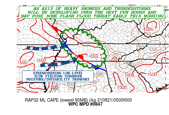
SUMMARY...An axis of heavy showers and thunderstorms is expected
to develop over the next few hours. Some localized repeating of
cells may result in some potential for areas of flash flooding
early this morning.

DISCUSSION...The latest GOES-16 Proxy Visible satellite imagery
shows an agitated axis of CU/TCU stretching northwest/southeast
across areas of far southeast MO/western KY down through
western/central TN and northwest AL, and there has been the
development of some rather warm-topped but very efficient shower
activity over the last hour.

There is an elevated stationary front showing up in the 850/925 mb
layer across this region and this boundary is expected to become a
focus for an expanding axis of heavy showers and gradually a few
thunderstorms over the next few hours. Facilitating this will be
the arrival of a strengthening westerly low-level jet upstream
from portions of the lower/middle MS Valley region. This low-level
jet energy will will drive an increase in warm-air
advection/isentropic ascent along with deeper moisture and
instability transport in an elevated fashion over the
aforementioned front.

PWs of 2.0 to 2.3 inches are pooled along and just southwest of
the boundary and will certainly favor efficient warm rain
processes for enhanced rainfall rates that may locally approach or
exceed 2 inches/hour.

There is some disagreement among the 00Z HREF suite of models with
respect to the timing of the more organized convective threat and
the resulting rainfall amounts going through 12Z, but generally
the expectation is for some spotty 3 to 4+ inch totals for this
time frame, and then a threat for additional rainfall beyond 12Z
as additional energy/forcing arriving from upstream maintains the
convective threat. Some localized repeating of convective cells
will be possible given the alignment of the activity in a
northwest/southeast fashion with the deeper layer mean flow.

Some areas of flash flooding will be possible as a result going
through the early morning hours.

Orrison

ATTN...WFO...HUN...LMK...MEG...MRX...OHX...PAH...

ATTN...RFC...LMRFC...NCRFC...OHRFC...NWC...

LAT...LON   37798877 37598760 36828646 35828574 35028574
            34618650 34738748 35728870 36688948 37428949
Last Updated: 220 AM EDT Sat Aug 21 2021
|


