| WPC Met Watch |
|
|
Mesoscale Precipitation Discussion: #0861 (2019) |
|
(Issued at 1048 PM EDT Tue Sep 17 2019
) |
|
| MPD Selection |
|
|
|
|
|

Mesoscale Precipitation Discussion 0861
NWS Weather Prediction Center College Park MD
1048 PM EDT Tue Sep 17 2019

Areas affected...Upper Texas Coast and Houston Metro

Concerning...Heavy rainfall...Flash flooding likely

Valid 180247Z - 180847Z

Summary...A potentially significant flash flood event along the
upper Texas coast and Houston metro may setup from late this
evening and overnight. Hourly totals in excess of 2" with totals
through 4 AM CDT 3-6" are likely. Isolated totals through 4 AM CDT
of 6-8" are possible.

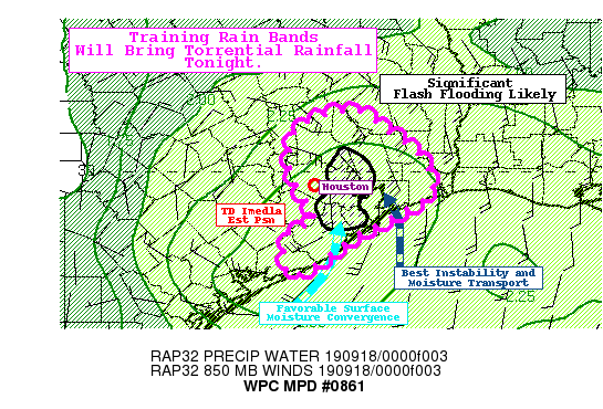
Discussion...As of 0230Z, the latest estimated position of TD
Imelda was west/southwest of Houston per recent observations and
radar imagery. Radar shows several training rain bands spiraling
onshore. In the last 6 hours, widespread 2-4" totals have been
observed, from mainly the south Houston metro toward the Galveston
coastal areas and near Freeport. In the last 18-24 hours,
widespread 4-6" totals have been observed with local maxes in the
6-7" range. All of this rain today has primed and conditioned the
soils, resulting in a much lower flash flood guidance.

A potentially significant flash flood event may setup overnight in
and around the Houston metro as the environmental conditions
remain more than sufficient for long duration heavy rain. PWs
analyzed from the 00Z soundings and blended TPW products were 2.2
to 2.4". The most recent mesoanalysis also showed favorable
instability in the region, especially from Houston eastward where
MUCAPE of 2000-2500 J/kg exists. With warm cloud depths well above
4 km, extremely efficient rain producing thunderstorms are
expected. Through the overnight, there will be a narrow axis where
the best moisture convergence overlaps with the favorable
instability and higher PWs, generally east/southeast of the low
center as it drifts north/northeast. This puts the greater Houston
metro area in this axis, further highlighting the potentially
significance.

The most recent hi-res models have a fairly tight cluster of 3-6"
totals through 4 AM CDT with some CAMs showing isolated 8" totals
(high-end scenario). The most recent HREF probabilities show
moderate probabilities of 1-hr totals exceeding 2-3" from around
the Houston area toward the Galveston coast.

All told, the combination of slow-moving TD Imelda with the
extreme environmental conditions for heavy rainfall over a highly
urban area could result in significant flash flood event. This
situation will continue to be monitored through the night.

Taylor

ATTN...WFO...HGX...LCH...

ATTN...RFC...WGRFC...

LAT...LON   30789504 30559466 30189419 29739405 29549433
            29379464 29199502 28909539 28669589 29209590
            29379555 29949586 30409585 30649566
Last Updated: 1048 PM EDT Tue Sep 17 2019
|


