| WPC Met Watch |
|
|
Mesoscale Precipitation Discussion: #0979 (2018) |
|
(Issued at 1133 PM EDT Sat Oct 13 2018
) |
|
| MPD Selection |
|
|
|
|
|

Mesoscale Precipitation Discussion 0979
NWS Weather Prediction Center College Park MD
1133 PM EDT Sat Oct 13 2018

Areas affected...Eastern Texas

Concerning...Heavy rainfall...Flash flooding possible

Valid 140332Z - 140715Z

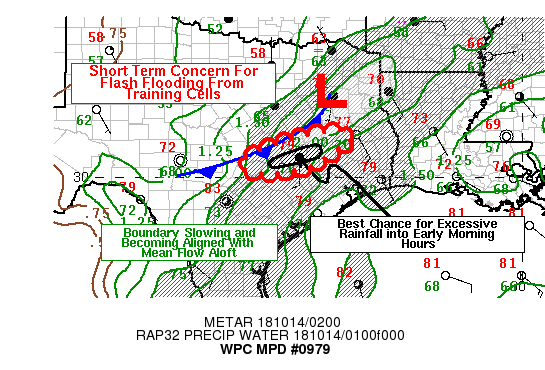
Summary...There are short-term concerns for localized flooding
problems over eastern Texas as a line of convection becomes
re-oriented to allow for training of cells.  In addition, a weak
impulse seen in GOES 16 Water Vapor imagery to the west of
on-going convection may enhance activity once it encounters the
front.

Discussion...As of 0320Z, a line of convection ahead of an
approaching cold front has begun to pivot and becoming oriented
close to the mean low level flow.  The atmosphere south of the
boundary has Precipitable Water at or above 1.5 inches and ML Cape
values were on the order of 3000 J per kg.

With the HREF probabilities highlighting this area for
probabilities of rainfall rates exceeding 1 inch per hour...and
even 2 inches per hour...there is some concern for flash flooding
where cells train or where convection repeats.

Short term high-resolution guidance shows the probabilities
dropping off after 06Z, presumably as the front pushes through the
area and any enhancement from the weak wave pass by the area.
After that, the high-resolution guidance shows weakening updrafts
and suggests that the convection will become more progressive
after 07Z.

Bann

ATTN...WFO...EWX...FWD...HGX...

ATTN...RFC...WGRFC...

LAT...LON   31359525 31199491 30989497 30799537 30559565
            30289621 30129729 30199782 30459803 31029687
Last Updated: 1133 PM EDT Sat Oct 13 2018
|


