RE-ANALYSIS OF THE GALE OF '78 - STORM 9 OF THE
1878 HURRICANE SEASON
David M. Roth
Hugh D. Cobb III
HPC, Camp Springs, MD
NWS, Wakefield, VA
1. INTRODUCTION
While in the process of conducting a historical survey of damaging tropical
storms for the state of Virginia, the authors ran across an intriguing
cyclone from October 1878. It was a cyclone which developed in the western
Caribbean and was not detected by the West Indies hurricane network before
its movements west of the isle of Jamaica on October 18. Once its presence
was known, the U.S. Signal Corps, a division of the War Department, tracked
its progress northward just off the Florida coast into North Carolina and
issued signals to warn of its arrival. This is a process the Signal Service
had been tasked with since November 1870, and one in which it had enjoyed
some limited success. The storm's similarities with other major storms
of more recent decades, such as Agnes (1972) and Hazel (1954) led to a
more exhaustive search for information about its impact on the Eastern
seaboard.
2. SOURCES OF INFORMATION
Information for this project was gleaned from books on local history,
old articles from Savannah, Charleston, Norfolk, Washington (DC), Wilmington
(DE), and Trenton newspapers, as well as other publications stored at the
Library of Congress and the National Archives in the District of Columbia.
Pressure values were then converted from inches of mercury to hectopascals
using the Smithsonian Meteorological Tables (List 1968). Wind data was
then converted from five-minute sustained winds to the one-minute sustained
winds used in the NHC track database (Powell et. al). Data was then utilized
for further research using the Nmap graphics display system, which is part
of the n-Awips software used by the Hydrometeorological Prediction Center
(HPC) in Camp Springs, Maryland.
3. STORM HISTORY
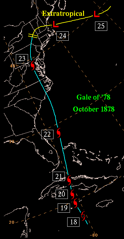
| In order to determine was influenced the storm's motion through
time, synoptic weather maps were drawn from Signal Service data for the
period of October 17-25. The cyclone's impetus for development, even after
this re-analysis, remains unknown. It is hypothesized that a tropical disturbance
was present around October 16 in the southwestern Caribbean, and was lured
northward by an approaching frontal system invading from the Gulf of Mexico.
The cold front stalled late on October 19, in the vicinity of Cuba as a
surface anticyclone drifted eastward through the Southeast. As the high
pressure system continued its march into North Carolina, pressure gradients
began to increase over south Florida as the cyclone edged north across
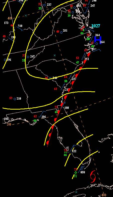
Cuba. As the tropical storm moved through the Florida straits on October
21, a coastal front formed off the coasts of the Carolinas and Georgia,
acting as a focus for rains well ahead of the storm. Key West sustained
26 m/s winds on that day, and it is likely gale force winds lashed much
of the Gold Coast at this time.
An extratropical cyclone in the mid-latitudes was located over the Mississippi
Valley on October 21. Its cold front accelerated south into the western
Gulf, and the deep southerly flow ahead of the system acted to increase
the forward motion of the hurricane into North Carolina late on October
22. As it linked up with a cold front late on October 23, the storm became
nontropical, and its track bent to the east as it moved along the main
cyclone's triple point. This is also when the heaviest rains shifted from
just east of the track to north of the low...in its cold conveyor belt
circulation. The storms this cyclone compared the closest to include the
September 1893 hurricane (storm 9), the October 1899 hurricane (storm 6),
and Hazel in 1954. The track of the Gale is to the right...numbered positions
reference location at 1200 UTC. Clicking on the track will give you
a better quality image. |
 |
4. ACTIONS OF THE U.S. SIGNAL CORPS
Cautionary signals were ordered for Key West at 0500 UTC on October
20. As winds increased at Key West, signals were ordered for that location
by 1600 UTC. By 1700 UTC, signals were ordered up from Jacksonville up
the coast to Charleston. Later on October 21, signals were raised from
Smithville to Kitty Hawk in North Carolina. At 0500 UTC on October 22,
cautionary signals were raised for the Great Lakes from Alpena to Sandusky,
then eastward to Oswego later that day. For the East coast, signals were
hoisted from Cape Henry to Boston. On October 23, signals rose from Portland
to Eastport.
5. LOWEST PRESSURES
As the hurricane made landfall between Wilmington and Cape Lookout,
the pressure fell to 983.8 hPa at Cape Lookout. However, the lowest pressure
measured from the center of the storm occurred in the northern Chesapeake
Bay, where the lowest sea level pressure of 974.6 hPa was observed. A common
technique for analyzing central pressures of cyclones, both at the HPC
and the MPC (Marine Prediction Center) is to subtract 1 hPa per 4 m/s (10
kt) of wind. If you apply this rule to Cape Lookout, which measured a five-minute
sustained wind of 47 m/s, a reading of 975 hPa is derived as the low moved
ashore. It is quite unlikely that the minimum central pressure of the hurricane
maintained itself during the eight hour voyage from landfall to the the
northern Chesapeake Bay. If the pressure rise reported from surface observations
during the low's trek over the succeeding six hours from the Chesapeake
into eastern Pennsylvania is correct (a 10 hPa rise), a value of 963 hPa
would be extrapolated just before the time of its landfall. Using Atlantic
wind/pressure relationship tables derived by Charlie Neumann and Chris
Landsea, this perfectly fits the 47 m/s wind observed (Landsea, personal
correspondence).
6. MAXIMUM EXTENT OF DAMAGING WINDS
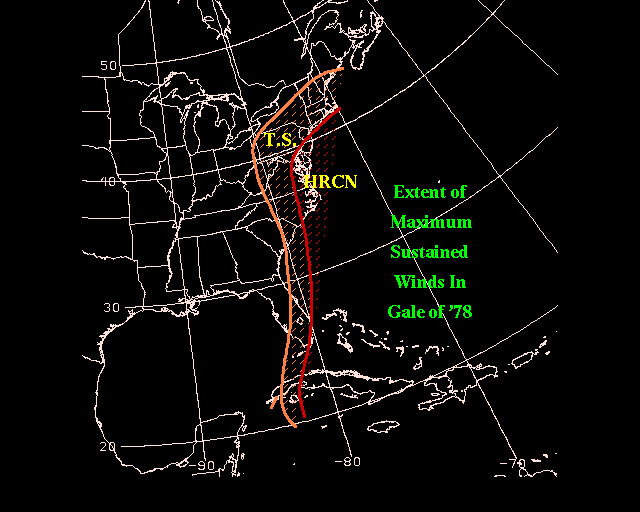
| To the right shows the area where maximum sustained winds reached
gale force (in orange) and hurricane force (in red). It is believed
that hurricane force winds lashed the Gold Coast of Florida due to the
high winds seen at Key West, and the reports of hurricane conditions in
Cuba. Gales extended northward through the Mid Atlantic towards the
Great Lakes. Hurricane force winds were seen almost entirely to the
east of the track, from approximately Wilmington, NC northward through
eastern Virginia, Chesapeake Bay, Philadelphia, Delaware, much of New Jersey,
and just off the New England coast. It should be noted that
most of the higher winds in New England occurred while the storm was still
centered over the Mid Atlantic. |
 |
7. RAINFALL FROM THE GALE
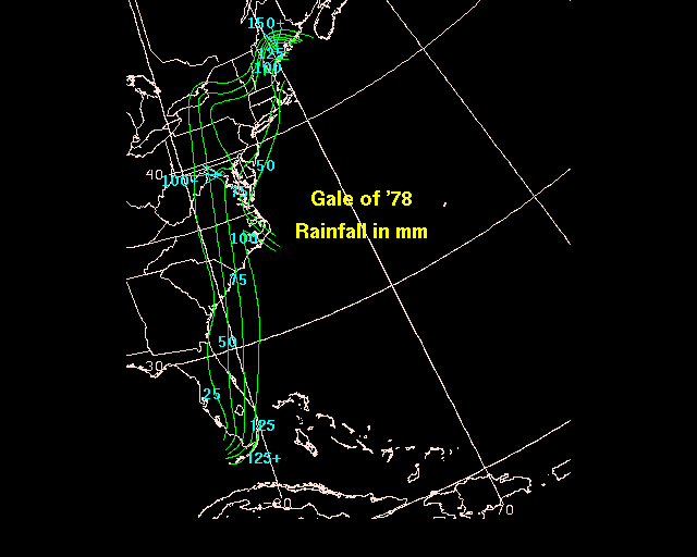
| The 25 mm contour extends diagonally across Florida from north
of Port Charlotte north-northeast to Jacksonville and Charleston before
going due north across the Appalachians into Lake Ontario (rainfall map
to the right...25 mm is approximately equal to an inch). In New England,
the northern edge of the precipitation was more dramatic. As the storm
became extratropical, a cold conveyor belt circulation formed north of
its warm front/occlusion, leading to heavy rains across southern Maine.
Regions where 100 mm were measured include southeast North Carolina and
much of southern Maine. The highest totals observed were 159 mm at West
Waterville, Maine, 127 mm at Emory Grove, Maryland, and 122 mm at Key West. |
 |
8. COMPARISON TO OTHER HURRICANES
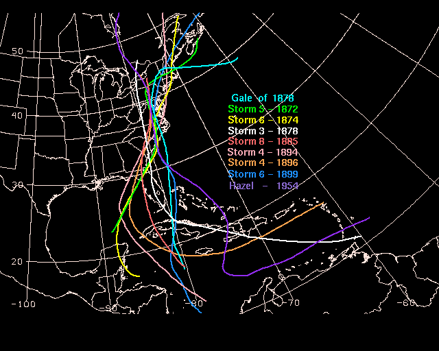
Sixteen hurricanes had similar tracks through the East as the Gale
of '78. If you restrict the sample to those which were similar throughout
the track, only seven others come close. Of this sample, with the
exception of the September Hurricane of 1878, all others formed in late
September or October. All produced hurricane force winds significantly
inland of their point of landfall. None formed in June, another month
climatologically prone to systems accelerating northward out of the tropics.
Agnes (1972) did not make the sample as it was much weaker, and swung off
the coast before making its final landfall in New England. Hazel's
track was included as it was the storm with the closest track (and effects)
to the Gale in the Twentieth Century. All other storms in the sample
occurred in the Nineteenth Century.
|
 |
9. DAMAGE AND FATALITIES
Seventy-one people perished due to the Gale of '78 (Rappaport et. al.
1995) in the eastern United States. A running tally of the death
toll will appear as they are covered in this paper. Those that were
lost to the storm were taken due to shipwreck and river flooding. In Philadelphia
alone, $2 million in damage was exacted (Noyes 1878), in 1878 dollars,
when over 700 structures failed. Along the coast, the Virginia barrier
islands of Smith and Cobb went underwater for the first time in memory,
taking all cattle out to sea (Barnes et. al. 1997). The following narrative
describes damage and storm effects region by region.
Cuba. On the night of the 21st, hurricane conditions
were reported at Havana. Much damage was done to buildings. Three schooners
sank. Pressure reports were missing during the storm's passage over the
isle...the lowest pressure noted was 29.67" at 4:25 p.m. on the 21st.
Observations were sporadic during the cyclone's passage over the island,
therefore the pressure most likely reached lower values that those received
at the Washington Signal Office.
| Florida. At Key West, northeast winds peaked at
24 m/s (54 mph) during the morning of the 21st. Their
storm total rainfall measured 122.7 mm (4.83"). High north to northeast
winds were also witnessed at Punta Rassa. Passing forty miles offshore
the Gold Coast, the Gale disrupted shipping (the map to the right shows
what was going on over the Southeast at the time). The steamer Nueva
Barcelona lost its rudder eight miles south of the St. Augustine lighthouse.
Off St. Johns Bar, a severe east-northeast gale backed to the north on
the night of the 21st/22nd...though winds did not
exceed 8 m/s (17 mph) in Jacksonville. Over a dozen vessels were driven
aground between the Florida Straits and Cape Canaveral (Barnes). |
 |
Georgia. At Savannah, light rain fell through the afternoon
and evening on the 22nd. Heavy rain set in by 2:45 a.m. the 23rd
and continued until dawn. High winds increased to "almost a gale",
before conditions improved later that morning (Estill 1878). Savannah
recorded 0.33" of rain and a pressure of 29.60" during the storm.
South Carolina. At Charleston, a steady rain fell throughout
the 22nd, with occasional squalls. The pressure fell to 29.56".
The steamer Juanita reported a "terrific northeast gale" between
Charleston and Tybee Island during the night of the 21st.
The bark Martha was abandoned at sea off the South Carolina coast.
Charleston only reported 0.43" of rain.
Louisiana. In the wake of the cyclone, cold air pooled
in Canada was brought southward into the Pelican state. A terrible
yellow fever epidemic had been in progress across the South all summer.
In New Orleans, it was ended by cooling temperatures behind this storm.
The total loss of life in the Crescent City was 3,915 that summer (Every
Evening Publishing Company).
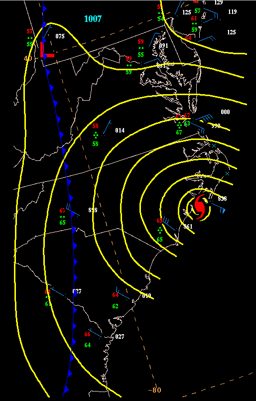
| North Carolina. The cyclone was centered between
Wilmington and Cape Lookout at 11 p.m. on the 22nd. The map
to the right shows the conditions over the Mid Atlantic at that time.
At Wilmington, the storm began at 3 p.m.. The maximum sustained wind of
16 m/s (36 mph) was reached at 10:40 p.m., with the lowest pressure of
986.1 hPa (29.12") reported at 11:56. At Cape Lookout, the pressure fell
to 983.8 hPa (29.05") at 11:02 p.m., when the wind went southeast at 30
m/s (68 mph). The highest winds in the last 5 ½ hours reached 45
m/s (100 mph) ...a rain total of 103.1 mm (4.06") was measured. In Portsmouth,
winds reached 37 m/s (82 mph) from the southeast at 11:04 p.m.. Smithville
peaked at 14 m/s (32 mph) from the east during the day of the 22nd.
Kitty Hawk greeted the storm at 6:30 p.m. on the 22nd. The winds
reached 39 m/s (88 mph) by 2 a.m. on the 23rd, just before the
anemometer was blown away. The pressure fell to 984.1 hPa (29.06").
One mile south of Cape Hatteras, the schooner Altoona went ashore
at 11:45 p.m., proving a total loss. The schooner Magnolia wrecked
in the Albemarle Sound that night; its captain drowned (1). The first officer
of the Mary A. Hood was washed overboard (2) off Hatteras. At 1:30
a.m. on the 23rd, the steamer Florence Witherbee went
ashore. The schooner William Collyer went ashore six miles south
of Barnegat at 2:40 a.m.. Two went overboard from the schooner Wyoming
trying
to enter Beaufort (4). The steamship Gen. Barnes foundered off Cape
Hatteras on the morning of the 23rd, also a total loss.
The steamship City of Galveston was reported lost in the storm on
the 23rd. The steamer
City of Houston encountered the gale on the
night of the 22nd, and was lost off Frying Pan Shoals after
it was abandoned by her crew ($200,000). |
 |
Virginia. The five minute sustained wind reached 38 m/s
(84 mph) at Cape Henry, while Norfolk experienced a 20 m/s (44 mph) gale
and a lowest pressure of 994.2 hPa (29.36"). Many of Virginia's life saving
stations were damaged, with one lifted from its foundation and moved half
a mile. An account of the storm's effects in the Norfolk area was provided
by the Norfolk Landmark.
| "....Only strong willed people could sleep while dwellings so violently
oscillated with the ravings of the tempest Tuesday night (22nd).
At an early hour a severe gale sprung up from the northeast and by 9 o'clock
old Boreas was knocking things around town in a lively style. The rain
came down in torrents and the streets at times were a driving sheet of
water. Yesterday morning (23rd), after the abatement of the
storm it was found that considerable damage and loss was involved in the
destruction of various sorts of property around the city and vicinity.
The maddening fury of the elements will long be remembered as making one
of the most severe storms in the annals of our city's experience...." |
There is another first hand account of the storm from Mr. Bolton, an
employee of the U.S. Signal Service, an early version of the National Weather
Service. Mr. Bolton was a repairman of the telegraph line between Cape
Henry and Kitty Hawk and was stationed at the Life Saving Station No. 3
in False Cape.
| "....I was at the station when the gale, which proved so disastrous
to human to human life commenced. A severe rain storm has prevailed all
day Tuesday (22nd) but the gale did not reach the station until
9 p.m. It rapidly increased in velocity until it almost became a hurricane.
The members of the crew at this station, whose duty it is to patrol the
beach that night, performed their duties with the upmost difficulty, as
they could scarcely make any headway against it, and often had to cling
to some stationary object like a telephone pole to prevent themselves from
being carried away at the mercy of the fearful tempest..." |
The A.S. Davis went ashore at Virginia Beach, killing 19 (23).
Gale force winds were experienced by 8 p.m. on the 22nd, with
the ship running ashore at 2 a.m. the next morning. Mr. Bolton described
the wreckage of the ship:
| "....The debris was thickly scattered along the beach for a distance
of fully 4 miles....I proceeded to Cape Henry, Virginia to assist the Signal
Officer there. The body of one of the crew was there. About 1 ½
miles south of Cape Henry the bodies of eleven of the crew had been washed
ashore.....During the heaviest part of the gale, the wind at Kitty Hawk,
North carolina registered 100 mph. The instrument itself was finally blown
away and therefore no further record was made. It was the severest gale
that had occurred on this coast for sometime." |
A heavy rain and wind blew through Richmond for several hours after
midnight on the 23rd. Winds became "almost a hurricane." It
was considered the hardest storm in years. Trees, fences, and telegraph
lines were downed across the city. The schooner Brewster saw
one of its passengers drown near Nanjemoy Beach (24). One of the
crew of the steamer Everman was washed overboard and lost (25).
Cobb and Smith Islands were completely submerged during this storm...higher
than seen in at least 20 years. All livestock was swept clean from the
islands. The steamer Theodore Weems lost its rudder and some of
her joiner work. At least 22 ships met their demise in this hurricane.
Washington, D.C.. Winds increased at 1 a.m. on the 23rd.
The peak of the cyclone was seen in Washington, D.C. at 4:40 a.m. on the
23rd. After that, winds swung around the compass a couple times
before settling on northwest by 7:15 a.m....the pressure fell to 975.3
hPa (28.80") at that time. Trees were uprooted and buildings unroofed
during the storm. Fields of corn were submerged in the ensuing flood
around the District of Columbia. Rock Creek became a raging river, but
produced little damage. Many young shade trees in the city were leveled.
Telegraph lines were felled between Baltimore and New York. Flooding from
the Potomac inundated many basements downtown along Pennsylvania Avenue.
County roads crossing the Stickfoot branch of the Anacostia River were
washed out.
| Maryland. Annapolis saw the winds swing from northeast
to southeast at 5:45 a.m., blowing with great violence. Its lowest pressure
of 976 hPa (28.82") was measured at 7:30 a.m.. Baltimore measured a maximum
sustained wind of 20 m/s (45 mph) at 5 a.m., and a lowest pressure of 976.3
hPa (28.83"). The storm was compared by some to a tornado.
All telegraph communication was cut off, except to the District of Columbia.
Many homes were unroofed; several were destroyed. Waters in Jones'
Falls began rising during the storm, and flooded the surrounding sections
of Baltimore. Wharves were submerged. Horse racing at Pimlico
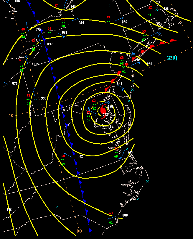
was suspended due to the weather. The map to the right shows the
extensive area of rain... at this time spreading from Virginia westward
to Ohio, and northward into New York and Connecticut.
On the Chesapeake Bay, the storm was considered "terrific", and was
felt worst between the mouth of the Patuxent River and Barren Island. Winds
began to freshen at midnight, reaching gale force from the east to southeast
at 2 a.m.. Immense waves broke over the upper deck of the steamer Express.
Winds reached hurricane force at 4 a.m.. The ship then wandered through
the middle of Chesapeake Bay. The barometric pressure fell to 974.6 hPa
(28.78"). Shortly after 5 a.m., when the winds shifted to the southwest,
waves tore away the saloon deck and flipped the ship on her side. After
rolling completely over, survivors gathered timber to make a tiny escape
craft. It sank immediately near Point No Point in St. Mary's county in
Maryland. The Quartermaster was rescued at noon that day, twenty miles
from the scene of the wreck. Five lives from the vessel were lost (30).
The steamboat Shirley was driven ashore Barren Island. A schooner
in Chesapeake Bay was reported to have drifted into the woods. The schooner
John
Russell was blown ashore at St. Jerome's Bay, just north of the mouth
of the Potomac, left high and dry in a corn field. Four or five other steamers
along with many other schooners were driven ashore in that vicinity. |
 |
Delaware. On Delaware Bay, this storm was one of the worst
ever experienced up to that time. Large numbers of vessels, of all shapes
and sizes, were driven ashore. The tempest was very destructive in the
First State. Many trees and fences fell victim. Telegraph lines
failed. Buildings were unroofed statewide. High winds led to
floods along the Delaware, Christiana, and Brandywine Rivers. Light
rain began on the evening of the 22nd. Winds increased overnight,
becoming a "terrific gale" by morning. Winds relaxed by late morning.
Much of South Wilmington was flooded; flood waters reached as high as
midway up the first floor. A large area southeast of the city was
described as a "vast sea." Buoys from the Government wharf at the
lighthouse were seen floating upriver. Two houses in Pickelville
floated off their foundations with their occupants along for the ride.
A washout at Shellpot delayed trains on the P., W., and B. railroad north
of Wilmington. The Knowles' woolen mill in New Castle burned to the
ground ($30,000 damage).
The schooner J. Dever was struck by the Gale while sailing up
the Christiana for harbor. The ship capsized, taking two of her crew
to the bottom (33). Six goats drowned. Port Penn eclipsed its
highest tide ever known by four feet. Schooners floated up to 1 1/2
miles inland. The tug W. P. Bolton was left a complete wreck
near the lighthouse. Its captain perished, as well as a boy aboard
(35). The Estelle Bright wreck 1/4 mile opposite New Castle
around 6:00 a.m. when a heavy gale and sea suddenly arose. Three
aboard drowned (38). Seven perished when the Buckeye foundered
off Tasker's Iron Works, near Fort Delaware, on Pea Patch Island (45).
In Middletown, damage was done to the Presbyterian church, Episcopal
church, and the Delmarva Drying House. The long bridge over the St.
Augustine creek and surrounding marsh was destroyed. Hundreds of
bushels of corn was swept down river, as well as several homes ($3,800
damage). It was considered of shorter duration than the September
1876 cyclone, but more severe as tides rose 2 feet above the 1876 benchmark.
Odessa saw many of its barns prostrated. and many heads of cattle perish.
Several vessels were driven ashore. Everything except the hotel was
swept away from Collin's Beach ($10,000 damage).
Dover totaled $1,100 in damage to new carriages, which were smashed
to pieces. Everything at the fairgrounds was in ruin. Four
drowned in Leipsic when the tide rose so quickly that the men inside could
not escape (49). At Lewes, it was the worst storm in forty years.
The storm began at that location at 2:00 a.m.. A seven foot storm
surge was measured at the beach, an event that hadn't been witnessed in
at least fifty years. At Rehoboth, the beach eroded away. The
railroad track bed at Maull's Glades was washed away. All bathhouses
along the beach disappeared.
Mispillion Light lost all their stock when the tide swept it away from
the base of the lighthouse. Cattle, horses, corn, and hay all were
flooded away along Mispillion Creek. A large tree fell through a
building in Milford, splitting it in two. Frederica saw its Methodist
church leveled. Twenty-four oyster boats were beached at Clayton,
but no lives were lost. The railroad pier at Bombay Hook was nearly
obliterated. Eighteen lives were lost statewide. Almost $45,000
in damage was seen across Delaware.
Pennsylvania. Damage from this hurricane was widespread.
At Scranton, trees were uprooted, houses were "dismantled", and many residences
lost their roofs. In Philadelphia, a strong east wind raged from 2 a.m.
to 8 a.m., before shifting to the south. Half-hourly observations were
taken at the Signal Corp office between 5 a.m. and noon. These revealed
the lowest pressure measured as 986.1 hPa (29.12") and a southeast wind
of 32 m/s (72 mph) at 7:40 a.m.. Oaks fell throughout downtown. At
least 700 buildings were destroyed while nearly fifty churches lost their
spires. Train sheds at the Pennsylvania Railroad Depot in West Philadelphia
were demolished ($32,000 damage).
Flooding submerged the first stories of buildings along the river front;
the height of the flood occurred at noon on the 23rd. Great damage
was done to buildings and the dykes around League Island, at the junction
of the Schuylkill and Delaware Rivers. The bridge at the falls of
the Schuylkill was swept away ($30,000 damage). The tide around the
island exceeded the highest known before by a foot by 10 a.m....almost
the entire island was submerged. The ship house on the isle was a "wooden
mass" after the storm passed by. The sloop Helen became a
complete wreck in its vicinity. High floods washed away the Madison
bridge near Pottstown ($100,000 damage). Nine canal boats sank in
its vicinity. Much of the oyster fleet was sunk during the tempest,
taking two lives (51). Five mules perished. At Media,
a house was leveled, trapping its owner in the ruins; he was later rescued.
Wilkes-Barre reported one life lost (52) and several injuries. A tornado
struck at 10:30 a.m., lifting up and moving a building bodily through the
air. At Reading, two more casualties were reported (54). Seventeen
vessels were sunk and twenty-two others were badly damaged. Chester estimated
$40,000 in damage as 90-100 buildings were unroofed; fifteen homes were
destroyed. Damage was estimated near two million dollars in Philadelphia.
Pottstown tallied more than $100,00 in damage. Extensive property
damage occurred in the Schuylkill, Lehigh, Lackawanna, Lebanon, and Wyoming
Valleys. Seven lives were lost in Philadelphia (61). At Erie, winds reached
15 m/s (32 mph) in the cyclone. A schooner was totally wrecked. Damage
totaled $2,140,000.
Ohio. Even in Ohio, the storm's wrath could be felt. In
the pressure gradient behind the low, winds reached 16 m/s (35 mph) at
Cleveland, where heavy rain prevailed.
| New Jersey. Camden suffered greatly with 150 buildings
unroofed. The storm set in at 2 a.m. with strong east winds, waking
up the populace. By 7 a.m., increasing winds began to unroof buildings,
topple smoke stacks, down telegraph lines, and level sturdy buildings.
The spire to the Fourth Presbyterian Church crashed through the place of
worship. The pressure there fell to 29.40" between 8 p.m. and 2 p.m.
on the 24th. Damage throughout town totaled $16,200.
Along the Camden & Burlington railroad, considerable damage was
witnessed around Moorestown. A train was lifted from the tracks below
Kaigh's Point by flood waters, and capsized. The roof of the hotel
at Wenonah blew off, as well as several other buildings in town.
A grove near the train depot in Glouchester was leveled. Glouchester
City's Iron Works had its roof peeled off by the winds ($3,000).
A similar event led to another $3,000 loss at the Anacona Print Works.
The mills of the Washington Manufacturing Company suffered $500 in damage.
The West Jersey railroad was undermined along the Newton Creek Flats.
Big Timber Creek overflowed its banks, inundating thousands of acres
of land. Considerable damage was also reported from Union, Essex,
Salem, and Hudson counties. Trees were uprooted at the Salem Presbyterian
Church, which also saw its share of destruction. Near Sharpstown,
a man was killed when his chimney crushed him on his front doorstep (62).
A brick house near Hancock's bridge was blown down; one child fell victim
to its collapse (63). Woodbury's town hall was unroofed.
Cape May sensed the beginning of the cyclone at 1 a.m., when a good
northeast breeze developed. When winds reached 65 m.p.h., an "extraordinarily
high tide" invaded the area. The highest winds preceded the storm,
as easterly winds of 38 m/s (84 mph) were measured at 5:45 a.m..
This drove the increasing tides between the city and the mainland, covering
the railroad track with three feet of saltwater. Barnegat Inlet commenced
feeling the force of the cyclone at 6 a.m. on the 23rd. Barnegat
recorded a southeast wind of 32 m/s (72 mph) while Atlantic City reached
a peak wind speed of east at 25 m/s (56 mph). Very high tides ravaged
the coast as the storm approached.
Six miles south of Barnegat, the schooner William Collier came
ashore at 9:40 a.m. on the 23rd. Disaster struck the schooner J.
R. Chambers and its load of potatoes. Her stern was stove in,
rudder unshipped, and the sails were torn away while off Stony Point.
The schooner Julia was driven ashore on the flats a few miles from
Sedge Island while the Samuel Carlton grounded on the north shore
of Barnegat Inlet. The schooner
H.F. Potter was totally wrecked
at Five-mile Beach; two drowned (65). Near Peck's Beach, the schooner Sarah
Clark
was demolished, four were lost (69). Vessels at Point Breeze
broke from their moorings. The Russian corvette Europe collided
with a pier, doing considerable damage. Numerous other vessels also
went ashore. On the storm's backside, tides dropped so much due to
the offshore flow that Barnegat Inlet became impassable. |
 |
New York. At 7 a.m., 22 m/s (50 mph) winds began in New
York City, which lasted several hours. In New York City, one of the
windows of Tiffany's was blown in ($1,500). Considerable damage was
reported. Oswego peaked at 13 m/s (29 mph). Rochester had 13 m/s (28 mph)
winds sustained at 2:30 p.m.. High tides led to significant damage
at the coast. The steamer Massachusetts went ashore Drum Point.
The steamer Louisa went ashore the Middle Ground.
Connecticut. New Haven reported east winds of 18 m/s (40
mph) at 11 a.m.. The storm was considered very severe. The schooner Mary
Tyce wrecked, which led to two
casualties (71). New London experienced east winds of 27 m/s (60 mph)...their
most severe storm in forty years.
Massachusetts. Boston reported southeast winds of 18 m/s
(40 mph) as the low slid back offshore. Western sections of the state
recorded over 75 mm (3 in.) of rain... with 87.6 mm (3.45") measured in
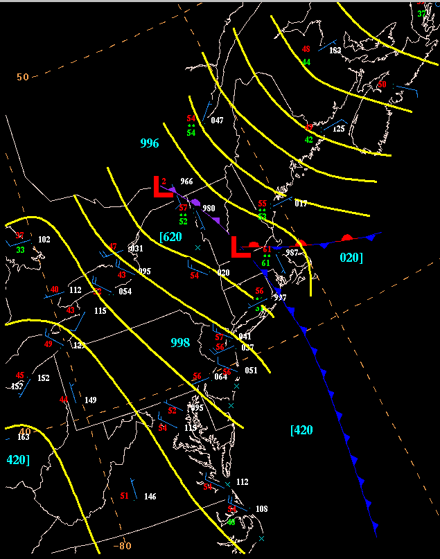
Menden. The map above shows the then extratropical low (the southern
of the two lows) moving southeast through Massachusetts. The steamer
Ide and 23 other schooners went ashore along the coast. The
schooner Joseph Fitch went to pieces off Stonington.
New Hampshire. At Mount Washington, at 6000 foot elevation
above sea level, 54 m/s (120 mph) winds lashed the observatory at 4:57
p.m. on the 23rd. At Dunbarton,
87.6 mm (3.45") of rain fell.
Maine. Winds at Portland reached 31 m/s (70 mph); the anemometer
was destroyed. A deluge fell across southern Maine, with 160 mm (6.30")
measured at West
Waterville....the highest total for any known location associated with
this cyclone.
10. PROPOSED SMOOTH TRACK OVER THE UNITED STATES
The following chart was created from all the data compiled from the
U.S. Signal Corps (Myer 1878) and the previously known track (Fernandez-Partagas
et. al. 1995). Surface maps were made for the time period prior to, during,
and slightly after the cyclone traversed the United States. From the positions
derived at map time, and winds observed by the Signal Service, the following
synoptic data were created for its passage over the United States.
| Date |
Time (UTC) |
Latitude (N) |
Longitude (W) |
Max. Wind (m/s) |
Central Pres. (hPa) |
| 10/23 |
0600 |
35.7 |
77.0 |
47 |
965 |
| 10/23 |
1200 |
39.0 |
77.2 |
45 |
975 |
| 10/23 |
1800 |
41.5 |
75.4 |
31 |
985 |
| 10/24 |
0000 |
42.7 |
73.6 |
29 |
990 |
| 10/24 |
0600 |
42.9 |
71.4 |
22 |
995 |
| 10/24 |
1200 |
42.5 |
68.8 |
18 |
999 |
11. References
Barnes, Brooks, M., Barry R. Truitt, 1997. Seashore Chronicles: Three
Centuries of the Virginia Barrier
Islands. University Press of Virginia: Charlottesville.
Estill, J. H., 1878. The Cyclone Gave Us the Go-By Savannah
Morning News 23 October 1878: 3.
_____. The Cyclone Savannah Morning News 24
October 1878: 3.
_____. Midnight Telegrams Savannah Morning News
25
October 1878: 2.
Every Evening Publishing Company, 1878. Last Night's Storm
Every
Evening and Commercial
23 October 1878: Wilmington, 3.
_____. The Storm Elsewhere Every Evening and Commercial
24 October 1878: Wilmington, 1.
_____. Tempest Tossed Every Evening and Commercial
24
October 1878: Wilmington, 3.
_____. New Castle Every Evening and Commercial
25
October 1878: Wilmington, 2.
Fernandez-Partagas, J., Henry Diaz, 1996. A Historically Significant
Revision of Atlantic Tropical
Cyclone Frequency 1851 to 1890. Climate Diagnostics Center,
ERL/NOAA, 62 pp.
List, Robert J., 1968. Smithsonian Meteorological Tables.
Smithsonian Institution Press: Washington.
Murphy, John L., 1878. The Storm Daily State Gazette
24 October 1878: Trenton, 2-3.
_____. The Cyclone in New Jersey Daily State Gazette
25 October 1878: Trenton, 2.
_____. More of the Great Storm Daily State Gazette
26
October 1878: Trenton, 2.
_____. Our Barnegat Correspondence Daily State Gazette
28 October 1878: Trenton, 2.
Myer, Albert J., 1878. Monthly Weather Review October 1878. War
Department: Washington.
Noyes, Crosby S. The Great Storm. Evening Star 23 October 1878:
Washington, 1,4.
_____. The Great Storm. Evening Star 24 October 1878: Washington,
1,4.
_____. The Cyclone in Philadelphia. Evening Star 25 October
1878: Washington, 1,2,4.
Powell, M.D., S.H. Houston, and T.A. Reinhold, 1996: Hurricane Andrew's
Landfall in South Florida. Part
I: Standardizing Measurements For Documentation Of Surface Wind Fields.
Weather and Forecasting,
11, 304-328.
Rappaport, Edward N., Jose Fernandez-Partagas, 1995. The Deadliest Atlantic
Tropical Cyclones,
1492-1994, NOAA Technical Memorandum NWS NHC-47, 42 pp.
Riordan & Dawson, 1878. The Weather News and Courier
23 October 1878: Charleston, 4.
_____. "Old Probs" Hit By a Storm News and Courier
24
October 1878: Charleston, 1.
_____. Echoes of the Storm News and Courier 25
October 1878: Charleston, 1.
Sanders, Ti, 1983. The Weather Is Front Page News.
Icarus Press: South Bend.
Tyler, David Budlong, 1955. The Bay & River Delaware:
A Pictoral History. Cornell Maritime Press:
Cambridge. |
|
|
For comments, questions regarding
this paper, send e-mail to David
Roth or Hugh Cobb
Last Updated May 27, 2000
HPC
Page
Other Research
