A tropical wave emerged off the African coast on August 14th. It was weak and moved westward through the monsoon trough in the eastern Atlantic. Entering the trade winds of the central tropical Atlantic on the 21st, it was associated with an elongated area of convection which increased in coverage the system moved through the Windward Islands on the 23rd. The thunderstorm area interacted with a broad area of low pressure near the northern coast of South America, bringing heavy rainfall to northern Venezuela. Thunderstorms became more concentrated with the convective system on the eastern side of the surface low in the southwest Caribbean Sea. Turning north-northwest on the 26th as it rounded the southwest side of the subtropical ridge, thunderstorm activity became better organized and the surface low became well-defined, with a tropical depression forming that morning southwest of Jamaica.
A tropical depression moved northwest for the next few days, becoming a tropical storm on the afternoon of the 26th. The cyclone passed by Grand Cayman on the 27th and as Ida approached the Isle of Youth, it gained hurricane intensity on the afternoon of the 27th. The center made landfall within the province of Pinar del Rio that evening. Later that night, Ida entered the southeast Gulf of Mexico. Land interaction and southwest vertical wind shear led to a halt to intensification during this time. As it moved farther into the Gulf of Mexico, intensification resumed on the morning of the 28th and Ida became a major hurricane by the 29th while not far offshore off Southwest Pass.
Ida moved ashore Port Fourchon during the early afternoon of the 29th as a strong hurricane. Turning north-northwest, Ida wouldn't start weakening until it moved out of the swamps of southern Louisiana. The storm regained tropical storm intensity as it entered southwest Mississippi early on the 30th. Then moving northeast, Ida weakened to a tropical depression in northeast Mississippi that afternoon. Ida accelerated northeast, undergoing extratropical transition in the Tennessee Valley and completing it as it moved into West Virginia on the morning of September 1st. Turning east-northeast, Ida strengthened somewhat and brought very heavy rainfall and gale-force winds near coastal sections of the northern Mid-Atlantic and southern New England states, along with several tornadoes. Its center moved across northern New Jersey and south of Long Island by the morning of the 2nd before moving farther out to sea thereafter.
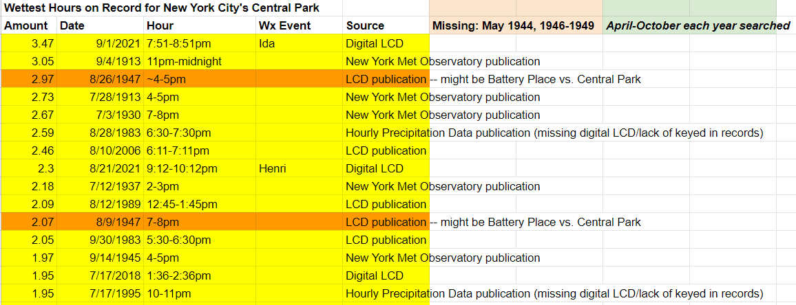
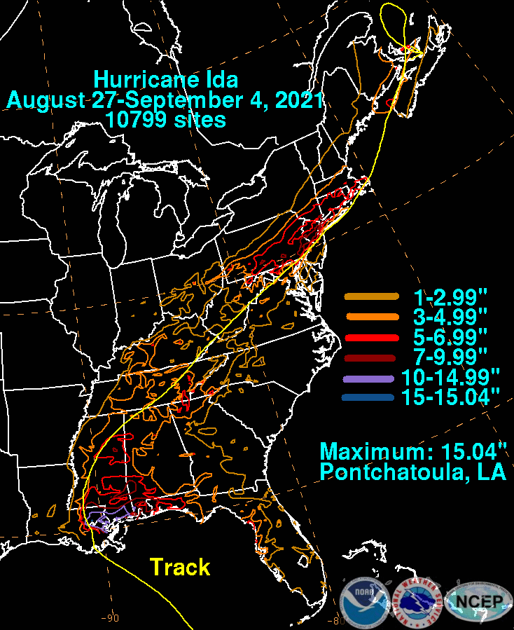
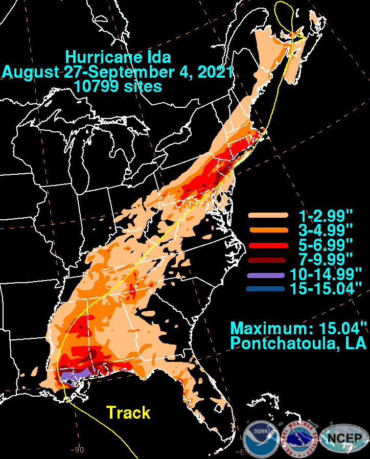
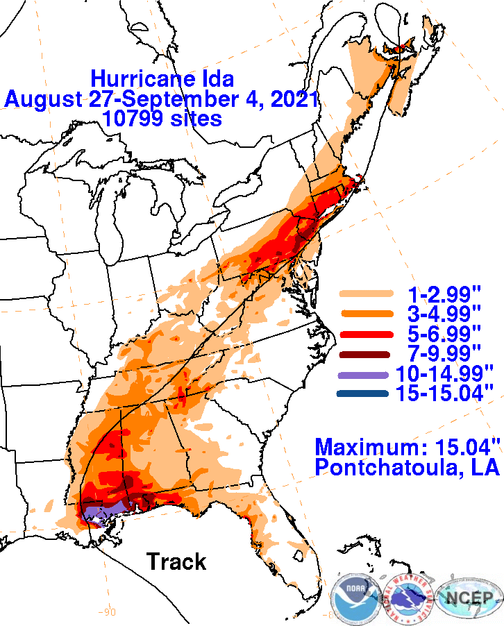
Heavy rains fell in association with Ida near its Gulf Coast landfall into the Tennesse Valley and then again just before its oceanfall as it moved offshore the northern Mid-Atlantic states. New York City's Central Park measured its wettest hour on record -- 3.47" between 7:51 and 8:51 pm on September 1, 2021. Overall amounts in the northern Mid-Atlantic States peaked just above 10". The graphics below show the storm total rainfall for Ida, which used rain gage information from the National Weather Service River Forecast Centers, Forecast Offices, and CoCoRAHS.
 |
 |
 |