Jeanne formed from a tropical wave that moved from Africa to the eastern tropical Atlantic Ocean on 7 September. The
wave moved uneventfully across the Atlantic until a tropical depression formed from it on 13 September as it approached
the Leeward Islands. From 13 to 18 September, the motion was toward the west-northwest at a slow forward speed of 5
to 10 kt, under the steering flow of a subtropical high pressure ridge located to Jeanne's north. The cyclone strengthened
to a tropical storm on 14 September while it moved slowly over the Leeward Islands. Continuing west-northwestward,
its circulation moved slowly over the Virgin Islands and the center moved inland over southeastern Puerto Rico on
15 September when maximum sustained surface winds reached 70 mph. The center moved across Puerto Rico, then
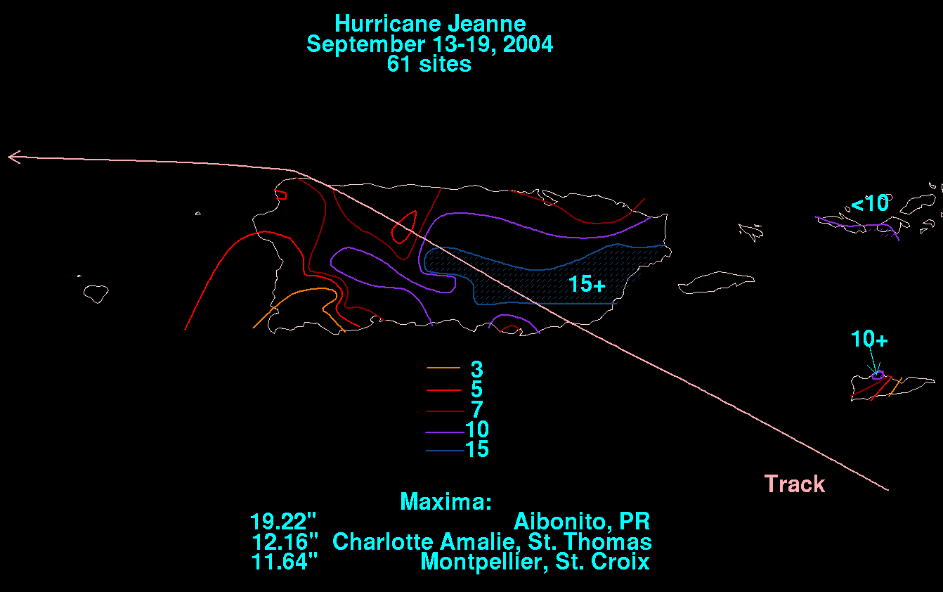
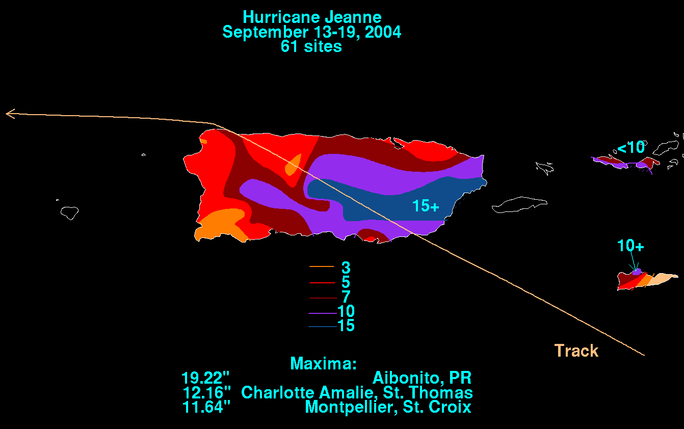
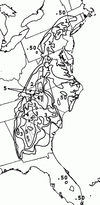
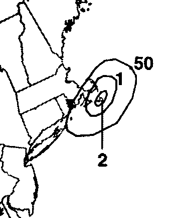
over the Mona Passage and inland at the eastern tip of the Dominican Republic. Below are graphics showing Jeanne's
rainfall over the northeast Caribbean Islands. Data was provided by the National Climatic Data Center in Asheville, NC.
 |
 |
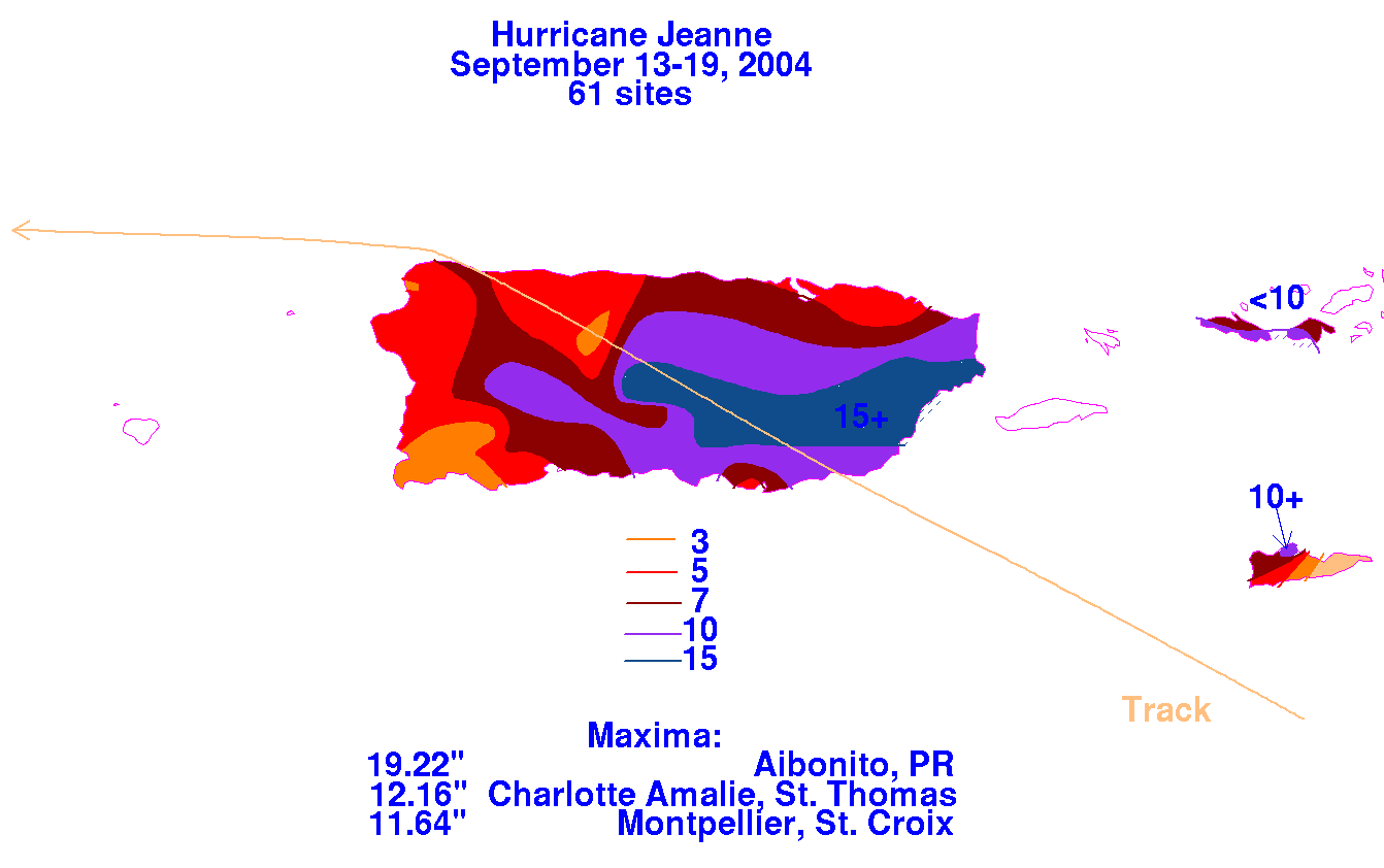 |
Jeanne was a hurricane with 80 mph winds while over the Mona Passage and during the Dominican Republic
landfall, but then weakened over the rough terrain of Hispaniola. By the early afternoon of 17 September, the
cyclone briefly weakened to a depression and moved over Atlantic waters just north of Hispaniola. On 18
September and in a weakened condition, the low level center moved westward away from the deep
convection and dissipated and a new center reformed well to the northeast of the dissipated old center.
Jeanne's slow forward motion across the Caribbean motion contributed to torrential rainfall along its path.
These rains and resultant fresh-water flooding and mudslides caused thousands to die in Haiti.
While Jeanne was dumping rain over the
Caribbean countries, Hurricane Ivan moved over the Gulf of Mexico
and inland
across the southeastern United States. By 18 September,
Ivan's mid-level circulation had combined with an extratropical
short wave trough in the westerlies and moved to the northeastern
U.S. coast where it eroded the ridge to the north of Jeanne.
This placed Jeanne in a weak steering flow that persisted for
five days.
Jeanne first moved slowly northward over the
southeastern Bahamas
as a tropical storm and then moved in an anticyclonic loop about
500 n mi east of the northwestern
Bahamas. Jeanne gradually
strengthened to a hurricane with 100 mph winds by the time it
completed this loop on 23
September.
By 23 September, the extratatropical trough
previously located over the northeastern U.S. coast moved eastward
and was
replaced by a large deep-layer migratory ridge that
propelled Jeanne on a track just north of due westward. On 24
September,
Jeanne moved over its own previous track from a few days
earlier and encountered cooler waters caused by upwelling from
the hurricane. This is believed to be a factor in the decreasing of the
maximum winds from 100 mph to 80 mph by the
evening of 23 September.
Continuing westward at 12 to 14 mph and moving away from the
upwelled cooler water, the
winds increased to 115 mph (category
three on the Saffir/Simpson hurricane scale) by the morning of 25
September as the
center moved over Abaco Island and then Grand
Bahama Island in the northern Bahamas. Jeanne made landfall on the
east
coast of Florida early on 26 September with the center of its
50-n mi diameter eye crossing the coast at the southern
end of
Hutchinson Island just east of Stuart at midnight on the night of 25
September.
Maximum winds at landfall are
estimated at 120 mph over a very small
area north of the center and it is not clear whether these
strongest winds reached
the coast or remained over water.
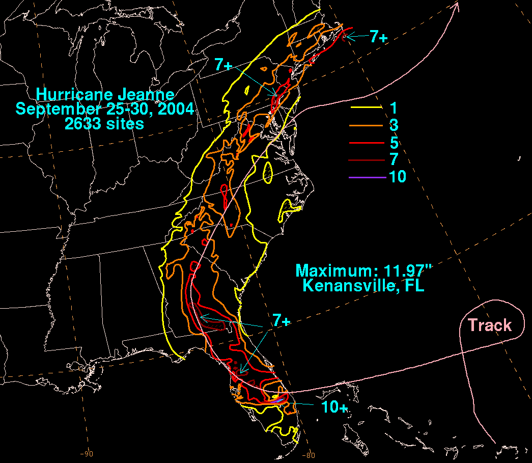
Jeanne moved across central Florida while
weakening and began to recurve around the western periphery of the
aforementioned migratory ridge. The hurricane weakened to a
tropical storm while centered about 30 n mi north of
Tampa early in the afternoon of 26 September and then weakened to
a tropical depression the next day while moving
northward across central Georgia
accompanied by heavy rain. The depression, still accompanied by
heavy rain moved
over the Carolinas, Virginia, and the Delmarva
Peninsula. It merged with a frontal zone and became extratropical on the
evening of 28 September while moving eastward off of the U.S
mid-Atlantic coast. Below is a track of the cyclone,
provided by the National Hurricane Center.

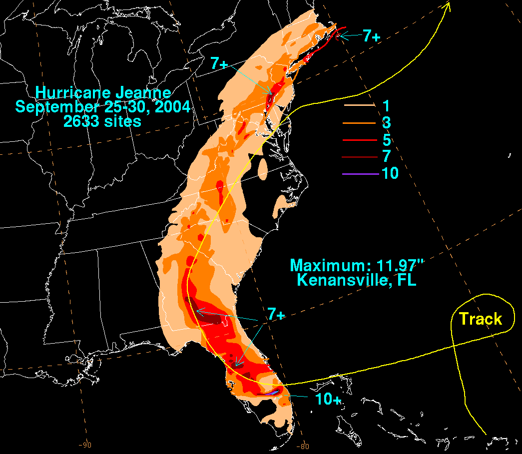
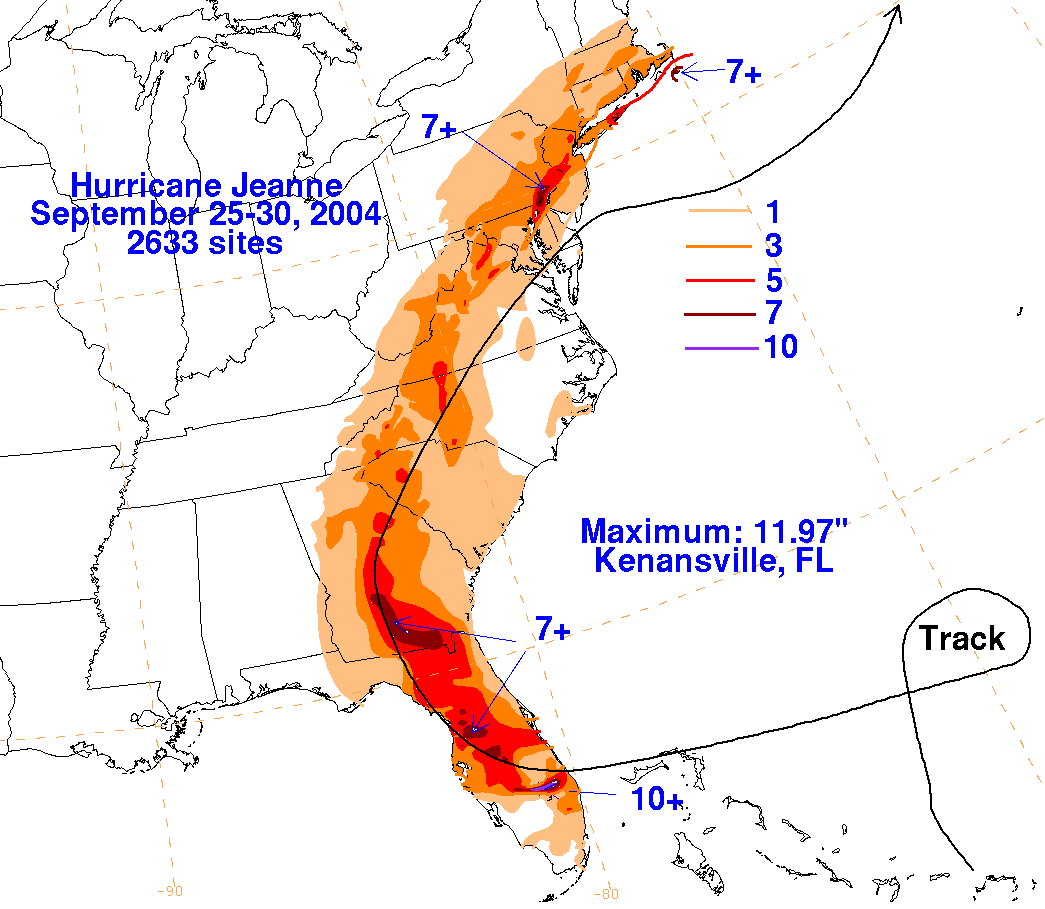
The storm total rainfall maps below were constructed using data
from
data
provided from NWS
River Forecast Centers, as well as additional
reports received by the
National Hurricane Center.
 |
 |
 |
Below are the calendar for Daily Precipitation Maps. Note that
the 24-hour periods end
at 12z that morning.