Rita was an
intense, destructive, and deadly hurricane that significantly impacted
the
Florida Keys and devastated extreme southeast Texas and southwest
Louisiana. It
formed off an old frontal zone, and developed into a tropical
depression on the 17th
just east of the Turks and Caicos Islands and moved westward, becoming
a tropical
storm on the afternoon on the 18th and a hurricane on the 20th as it
moved through
the Florida Straits. The center of Rita passed 50 miles south of
Key West before it
emerged into the Gulf of Mexico and began to rapidly intensify.
Maximum sustained
winds increased to 175 mph on the 22nd while moving through the central
Gulf of
Mexico, and its pressure fell to 897 hPa, the 3rd lowest on record for
the Atlantic
Basin and the lowest reported from the open waters of the Gulf of
Mexico.
Easterly gales into
Lake Ponchartrain led to renewed flooding in the 9th ward of
New Orleans. A significant shearline lured Rita more
northwesterly, and it weakened
as it moved away from the warm waters of the loop current.
Landfall occurred at 230
am CDT between Sabine Pass and Johnsons Bayou, LA while a category 3
hurrricane.
Rita slowly weakened as it accelerated inland, and maintained at least
tropical storm
strength when it crossed back into northwest Louisiana. The
cyclone moved northeast
and merged with a frontal wave on the 26th. Below is its
track, provided by the National
Hurricane Center.
The first three storm total rainfall maps below were constructed using
rain guage data provided from
NWS River Forecast Centers, as well as additional reports received by
the local forecast offices from
their post-tropical cyclone reports. The fourth image used radar-
derived information.
 |
 |
 |
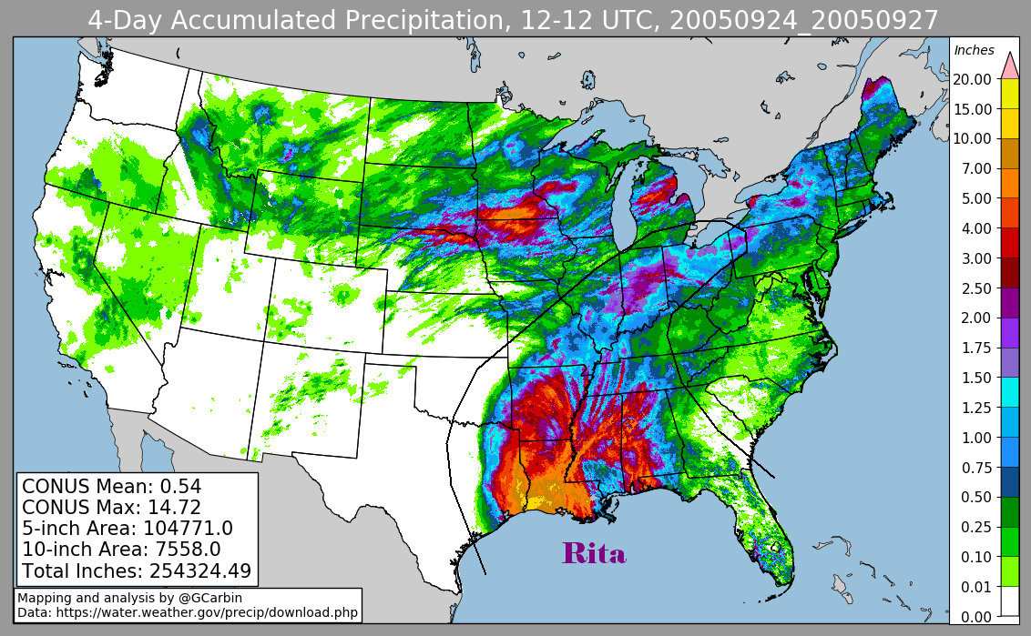 |
Below is a calendar
showing daily rainfall from this cyclone as of 1200 UTC, or 8 a.m. EDT.
| Sun |
Mon |
Tue |
Wed |
Thu |
Fri |
Sat |
| 20 |
21 |
22 |
23 |
24 |
||
| 25 |
26 |