| WPC Met Watch |
|
|
Mesoscale Precipitation Discussion: #0252 |
|
(Issued at 725 PM EDT Thu May 09 2024
) |
|
| MPD Selection |
|
|
|
|
|

Mesoscale Precipitation Discussion 0252
NWS Weather Prediction Center College Park MD
725 PM EDT Thu May 09 2024

Areas affected...Central Alabama...Eastern Mississippi...

Concerning...Heavy rainfall...Flash flooding possible

Valid 092325Z - 100430Z

SUMMARY...Initially slow moving, intense thunderstorms to become
more numerous with potential collisions and mergers after dark.
Widely scattered incidents of flash flooding will become possible
through late evening into early overnight.

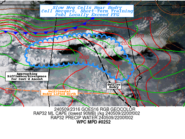
DISCUSSION...GOES-E Visible imagery aids in boundary detection
with old outflow boundary angled from the FL/GA/AL corner
northeast to near Birmingham before starting to meld/intersect
with the trailing edge of the northern stream cold front before it
flattens east to west from K1M4 into northern MS.   Additionally,
milky appearance and some increased congestus denotes a west to
east boundary that looks to be something the emanated from the
Gulf this morning.  There appears to be a discontinuity in the
moisture/theta-E field in the lowest levels but not enough to be
remarkable.  Still between these boundaries, full sun and Tds in
the mid-70s has resulted in ample unstable if capped environment.
However, GOES-WV and AMV along with RAP analysis fields denotes
the approach of a mid-level lull in flow with subtle diffluence
and speed divergence to locally enhanced mid-level cloudiness
along the leading edge of 700-500mb moisture.  The combination is
resulting in scattered destabilization with best cells initially
near BMX and low-level flow converge in the outflow boundary
(nearly perpendicular as well with favorable westward curvature).
Additional cells are breaking out across E MS.

Total moisture to 1.75" and strong updrafts to support moisture
flux into the column should support robust rainfall rates of
1-1.5"/hr probable.  Quick cell motions may result in reduced
rainfall totals, especially upstream with development over central
MS into E MS, but in proximity to the outflow boundary, cells are
likely to cluster/slow trying to anchor to the boundary much like
the rotating cell in Shelby county.  This will increase duration
as well a potential mergers, resulting in short-term increase up
to 2".

Hydrologically, west-central AL/eastern MS has been fairly dry,
but eastern AL remains fairly wet; especially with this morning's
heavy rainfall in the eastern quarter.  MPD area aligns with 1-3hr
FFG values of <2.5 and <3.5 respectively; where rain-rates/totals
could be 1.5-2" and 2-3".  Coverage of heavy rainfall is likely to
be widely scattered with local focus where cells remain stationary
or have upstream flanking line redevelopment that favors 1-2 hour
repeating/training potential.  Still the risk for flash flooding
is non-zero and is considered possible locally within the area of
concern through the early overnight period.

Gallina

ATTN...WFO...BMX...JAN...

ATTN...RFC...LMRFC...SERFC...NWC...

LAT...LON   33848712 33668600 32918546 32518527 32238577
            32828687 32748890 33178923 33518891 33698817
Download in GIS format: Shapefile
| KML
Last Updated: 725 PM EDT Thu May 09 2024
|


