| WPC Met Watch |
|
|
Mesoscale Precipitation Discussion: #0254 |
|
(Issued at 923 PM EDT Thu May 09 2024
) |
|
| MPD Selection |
|
|
|
|
|

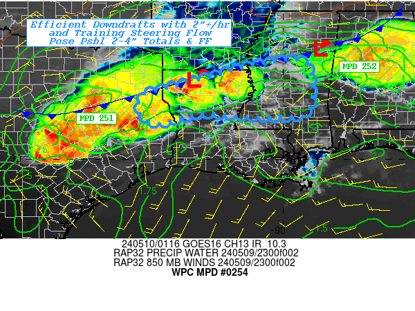
Mesoscale Precipitation Discussion 0254
NWS Weather Prediction Center College Park MD
923 PM EDT Thu May 09 2024

Areas affected...Western & Central MS...Northern LA...Far Eastern
TX...

Concerning...Heavy rainfall...Flash flooding possible

Valid 100125Z - 100630Z

SUMMARY...Deep layer flow parallel to the front with weak but
sufficient perpendicular convergence at cloud layer with ample
deep moisture may promote training of intense rainfall resulting
in localized 2-4" totals and possible flash flooding.

DISCUSSION...Boundary layer decoupling is occurring along slowly
southward sagging cold front across NE TX, N LA into N MS.  Highly
unstable and deeply rich moisture content is converging weakly due
to southerly 850mb flow at 10-15kts but generally orthogonal to
the boundary and with reduced capping at dusk, the convergence is
sufficient to break out thunderstorms.  MLCAPE of 3500-4000 J/kg
and Tds in the upper 70s allowing for TPW of 2" will support
intense rain cores of 2"/hr even with limited moisture flux on the
southerly inflow.

Generally, the area is in a solid stretching/shearing boundary
that supports this convergence in the low levels with stronger
flow aloft between exiting wave to northwest and deepening wave
over central TX.  As such, steering flow is strong but parallel to
allow for training profiles of the stronger convection.
Additionally with weak inflow, propagation vectors align with the
500-1000 thickness pattern gradient parallel to the deformation
zone and will support training profiles initially.   Given the
moist profile, slow cold pool generation will occur and allow for
some duration for the training.  Eventually, they will form and
either the convection will propagate southeastward or a new cycle
of updrafts will form along it.  As such, streaks of 2-4" are
going to possible mainly in a 2-3 hour period.   Given the higher
FFG and recently dry conditions, scattered incidents of flash
flooding may be possible through the early overnight period.

Gallina

ATTN...WFO...JAN...SHV...

ATTN...RFC...LMRFC...WGRFC...NWC...

LAT...LON   33239056 33218920 31668912 31459000 31519166
            31559280 31219416 31459474 32069481 32279436
            32779241
Download in GIS format: Shapefile
| KML
Last Updated: 923 PM EDT Thu May 09 2024
|


