| WPC Met Watch |
|
|
Mesoscale Precipitation Discussion: #0255 |
|
(Issued at 1157 PM EDT Thu May 09 2024
) |
|
| MPD Selection |
|
|
|
|
|

Mesoscale Precipitation Discussion 0255
NWS Weather Prediction Center College Park MD
1157 PM EDT Thu May 09 2024

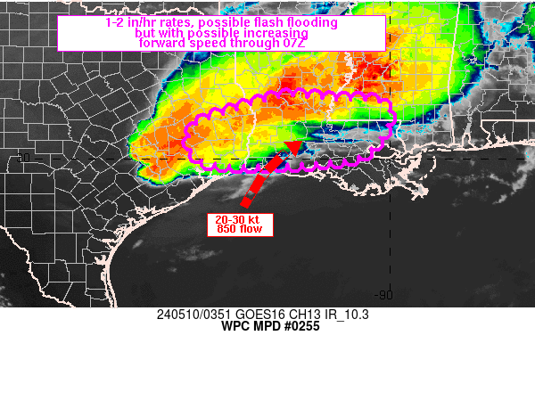
Areas affected...southeastern TX into south-central LA

Concerning...Heavy rainfall...Flash flooding possible

Valid 100353Z - 100700Z

SUMMARY...Flash flooding will be possible across southeastern TX
into south-central LA as a cluster of thunderstorms organizes.
However, there is potential for increasing forward propagation
through 07Z which would limit flash flood concerns.

DISCUSSION...Radar imagery at 0345Z showed that a cluster of
thunderstorms over the Piney Woods region of southeastern TX has
begun to increase in forward speed toward the southeast over the
60-90 minutes. Two discrete supercells farther west, between
Houston and San Antonio on either side of I-10, were tracking
southeastward as well, with the lead cell (south of I-10) largely
dissipated as it moved farther south into a more capped
environment...as represented on the 00Z CRP sounding. The western
cell(s) does not appear to pose a flash flood threat and is
expected to follow a similar weakening trend as the one south of
I-10 in the short term, with continued southward extent.

Farther east, there are indications that the cluster of cells over
southeastern TX will continue to track east or east-southeast
within a weakly capped environment (per 03Z SPC mesoanalysis),
following Corfidi vector approximations, but modifying for the
stronger 850 mb winds observed at the KLCH VAD wind than RAP
estimates which were about 10 kt weaker.

HRRR forecasts are mixed if the cluster over southeastern TX
weakens in the short term or maintains a similar intensity as it
encounters a better low level moisture feed into LA. Either way,
it appears at least a limited flash flood threat will exist with
potential for peak/isolated 2-3 inch rain totals within short term
training, possibly augmented by convection over central LA,
dropping south. Due to elevated soil moisture values from recent
heavy rainfall, sensitivity to flash flooding appears to be higher
than average, but overall forward propagation is expected to limit
the flash flood threat, especially with potential for increasing
forward speed through 07Z.

Otto

ATTN...WFO...HGX...JAN...LCH...LIX...SHV...

ATTN...RFC...LMRFC...WGRFC...NWC...

LAT...LON   31649281 31549153 31469015 30719016 30109072
            29939164 29849350 29899474 30239520 30659525
            30999488
Download in GIS format: Shapefile
| KML
Last Updated: 1157 PM EDT Thu May 09 2024
|


